
 On The Road
by: Bill Oetinger 11/1/2004
Central Virginia
The Blue Ridge Parkway. For all of my cycling life, I have heard folks talking about this mythic road running down the mountains through Virginia and North Carolina. I’ve always understood it to be a worthy cycling destination, but I paid little attention, as I never imagined I would find an opportunity to go there. So many roads and so little time, and that one so far from California.
But recently that changed. My wife took on an assignment that had her commuting, week-on and week-off, from our home in California to an office in Madison, Virginia, and during one of those weeks, I tagged along for a working vacation. (She was working; I was on vacation.) Turns out our home away from home was smack dab in the middle of a dream cycling region, including the Blue Ridge just a few miles away.
As it turns out, I only logged a handful of miles on the actual Blue Ridge Parkway, so this is not intended as any sort of definitive opus on that famous road. There are loads of good books that will do that, and a brief internet search will unearth dozens of links on the subject. (According to what I read, the best book on the subject is Bicycling the Blue Ridge: A guide to the Skyline Drive and Blue Ridge Parkway, by Elizabeth and Charlie Skinner, available through Adventure Cycling’s Cyclosource catalog.) Having seen so little of it, I will try not to generalize from the particular: try not to describe the whole elephant when all I got to see was his tail.
But I did ride over 300 miles in four days in the general neighborhood of the Blue Ridge--and hiked and car-toured in the area for another three days, when my wife was free from work--and I had such a good time there, and was so impressed with what I encountered, I felt it would be worthwhile to attempt some sort of summary of that brief adventure. Perhaps what little I learned will assist someone else in planning a trip to the area.
If there is one thing I learned on this trip--one thing I would like to convey to others--it’s that there is so much more to the area than just the famous Blue Ridge Parkway, and that if you go there and only do the Parkway, you’ll be missing a great portion of what the region has to offer a cyclist.
First, an overview...
 The Blue Ridge Mountains--eastern outrider of the Appalachian Mountain chain--run from just SW of Washington, DC in a long, NE to SW line, all the way down to Tennessee. (At the southern end of the range, they stop being the Blue Ridge and become the Black Mountains and then the Great Smokies, but that region is beyond the scope of this article.) For about 575 miles, a lovely, two-lane road meanders along the spine of the mountains. Beginning at the northern end, near Front Royal, Virginia, the first 105 miles are Skyline Drive running through Shenandoah National Park. When Skyline ends at the park border at Rockfish Gap, the Blue Ridge Parkway begins, and it runs for another 470 miles south to its terminus in Great Smoky Mountains National Park in Tenneessee. Of those 575 miles, I did over 100, mostly on the Skyline Drive section.
 Dennis Coello, that excellent cycle-touring writer, claims that Skyline Drive and the Blue Ridge Parkway are significantly different, although they appear superficially to be quite similar. Both stay as close as possible to the ridgeline. Both pass through the same landscape of hardwood forest, interspersed with high meadows, granite cliffs, and panoramic vistas over the valleys and foothills off both sides of the ridge. Both are supervised and maintained by the National Park Service and look the part: nature at its most perfect and pristine, with the road and the occasional campsite or lodge introducing the usual park-like elements, including lots of lovely old stone walls along the road, built mostly in the 30’s as a CCC make-work project. (I love old stone walls, and these are of the finest quality.)
Skyline Drive is more insulated from the outside world by virtue of being fully contained within Shenandoah NP. Everything you see is perfect and public and...a park. On the Blue Ridge though, only the actual road is a national park. Almost everything off the pavement is either national forest or private lands. That leads to a slightly more varied, less “perfect” landscape, with private homes and some agricultural elements along the way. More significantly, for a cyclist, the topography is gentler along Skyline and more varied and challenging along the Blue Ridge. Most of Skyline rolls up and down between around 2200’ and 3400’, but the climbs and descents, while often over five miles long, are never over about 5% in gradient. On the Parkway though, the highs and lows range from under 1000’ to over 6000’, with some of the grades being both long and steep (at least steep compared to Skyline).
Overall though, the two roads are more alike than not. For the cyclist, the attractions throughout are three-fold: first off, the sensational scenery; then the very bike-friendly road itself; and finally, very light, unobtrusive traffic.
The scenery ranks right up there with the Garden of Eden in its perfection of form and color. Everything looks right. Over 100 kinds of trees--mostly broadleaf hardwoods such as oak, hickory, maple--create a lovely forest of dappled light and pleasing texture. Turning leaves in the autumn and blooming azaleas and dogwoods in the spring and a confetti sprinkle of wildflowers in the summer add vivid hues to these picture postcard landscapes.
Granite muscles up through the thick understory, forming large and small cliffs and standing stones. The park brochures tell me it’s granite anyway, although it looks darker and more weathered than the bright, crisp granite we know in the Sierra. Not surprising, seeing as how these grandmother mountains are around a billion years old.
 Every couple of miles there is a vista point overlooking the valleys off either side of the ridge, to the west, the Shenandoah Valley, and to the east the Piedmont plains. All of the vistas are as pretty as the close-up views on the ridge. Down there in the foothills and valleys there is less wilderness and more meadows and pastures for cattle and crops, and little clusters of habitation around farm complexes or towns. It has the look of a classic human-friendly environment: fertile and well-watered...an easy place for a pioneer to settle in and prosper.
Wild critters go about their wild business: on my rides I saw families of whitetail deer, eastern marmots (aka groundhogs), and several species of snake. Black bear are common, although I didn’t see any. Butterflies fluttered by as I pedaled along...swallowtails, red-spotted purples, and anglewings being just a few that I could identify.
The road itself is a delight for cycling. Smooth pavement, nice curves, and constantly changing grades keep it entertaining, although, frankly, I could have wished for just a little more...what? Excitement? Challenge? The climbs are never difficult and the descents are never hairball. It’s all very pleasant and mellow and, I hate to admit it, almost bland. The scene is so perfectly serene and pretty that I found myself sometimes wishing for a little more pizzazz...the shiverof danger or the spice of variety. I don’t know...something to jazz things up.
One certainly doesn’t get that from the passing traffic, and that’s one sort of spice I don’t mind missing. The speed limit on Skyline is 35 mph and 45 on the Blue Ridge, and no commercial traffic is allowed, except for the rare truck servicing one of the infrequent park lodges. When I was there--on weekdays in mid-September--the traffic was extremely light, and all drivers seemed friendly and patient with the few cyclists on the road. There were more moto-tourists, on everything from ducks to hogs, than there were cars. I understand the traffic can be a lot heavier at times, for instance on weekends during the height of their famous fall color display, which was just beginning when I was there.
 So that’s the big picture up on the ridgeline: a landscape of nearly perfect and tranquil beauty. But also one that, at least by my standards, is just a little too perfect and tranquil...a little lacking in piquancy and spark. (And let me add one more little complaint about the ridgeline. I’m a great fan of creeks and waterfalls and flowing water, and this area is lush with them. But if you stay right up on the Parkway, at the crest of the ridge, you will miss most of the best falls and streams. Water flows downhill--duh!--and at the highest elevations, it’s all below you, somewhere in the canyons down the mountainsides.) I will accept the word of those who have done the whole Blue Ridge that it gets more varied and challenging as it goes along, but up in Shenandoah NP, I felt like paraphrasing bad old Ronnie Raygun: “If you’ve seen one mile of Skyline Drive, you’ve seen them all.”
Which brings me back to my original premise: that to do just the Parkway/Skyline and nothing else would leave one shortchanged on what the region has to offer. For me, a better plan is to do short chunks of Skyline or the Parkway, then drop off the ridge down into the neighboring valleys, and eventually work back up to the ridgeline. Or start in the valley, climb to the ridge while you’re fresh, and wrap up the day’s miles with a dancing descent back to the lowlands.
The challenge is in knowing how to put the pieces together. Riding the Parkway and Skyline requires no map at all, although the ones provided by the Park Service are very good and nice to have for planning your days. But there are no turns to navigate. Just stay on the main road for 600 miles! Going off the ridge and down into the surrounding counties though...that gets complicated.
My travels had never taken me nearer this region than the usual tourist crawl around our nation’s capitol--over an hour to the north--and as I had never planned on visiting rural Virginia, I had never done the least bit of research on the cycling possibilities. It was nearly a blank page for me, and when the whole trip came up rather suddenly, I had little time to plan routes or even get the general lay of the land. But a few days of busy googling finally connected me to some local cyclists who were kind enough to give me a few pointers and steer me to some websites with regional bike maps. (If you go to http://www.rideva.com/, you’ll find yourself at the home page of a good bike store in the town of Culpeper where they maintain a Map Library of very useful bike routes in the area.) So by the time I had my bike out of its airline box and reassembled at our inn near Stanardsville, I did have at least the barest outline of a plan. And in the end I improvised four very nice rides...three of about 75 miles each and one of about 90 miles.
The other challenge in coming down off the ridge is getting back up to it...read: major climbing. Not all of the roads that cross the Blue Ridge involve extreme climbs, but all are long and gain at least a couple of thousand feet along the way. I did do one climb that was seriously butch, and that’s the legendary Wintergreen climb (Hwy 664). I sought it out, as I recall it being a marquee attraction on the old Tour Dupont. That was on my third day of riding, and up to that point, I hadn’t encountered any climbs that really tested me, even one the Culpeper bike shop had labeled “extreme!” (Ruth Road, out of Madison). So I was thinking maybe they really didn’t know how to do real hills here, and I was wishing for something a little more challenging. Well...be careful what you wish for! This was the real deal. About six miles long, with the top four being double digit steep, and the last three truly sick. The sign at the top said 15%, and I won’t argue with that. That bad boy fried my bacon. And to top it off (literally), when I got to the summit at Reed’s Gap, I had to climb another three miles along the Parkway (at about 5%) before finally getting to descend back to my car.
But the real payoff for a cycle-tourist in getting off the ridgeline is not just a few rollicking descents and killer climbs. It is the rich, dense network of backroads through the little, rural counties that abut the Blue Ridge Mountains. My exploration was confined to Madison, Greene, Albermarle, Nelson, and Rappahannock Counties, all off the SE side of the ridge. My local contacts assure me the scenery and cycling are just as nice over the ridge in the Shenandoah Valley, further south down the ridge, and in pretty much any direction. But these are the counties I got to see, so I will only attempt to describe them.
 To put this in a perspective that at least means something to me--relating it to my own backyard--I note that these five little counties add up in square miles to just about the same area as Sonoma and Marin Counties combined: around 2000 square miles. (If you’re not from California, those are the two counties just north of the Golden Gate, across the bay from San Francisco.) And yet, while these two mostly rural California counties support a population of over 700,000, the five rural Virgina counties are home to less than 140,000. Same area...one fifth the crowd. When you think about all the open space in Marin and Sonoma--from Pt Reyes National Seashore to the Mayacamas Mountains--you can begin to appreciate just how quiet and uncluttered it is in those sleepy little valleys of central Virginia.
Charlottesville, with a population of 40,000, is the biggest city in the region. Home to the venerable University of Virginia, it has that feisty cultural stew and edgy style common to all good college towns. Frankly, it looks and feels much more interesting and sophisticated than any of the larger cities in Marin or Sonoma. It does have its share of tacky sprawl out on Route 29 that would look right at home in any California suburb, but the downtown core is magnificent: a combination of lovely historic architecture, the grand old university campus--founded and laid out by Thomas Jefferson--and some very enlightened urban renewal that has made it a model of pedestrian and bike-friendly spaces.
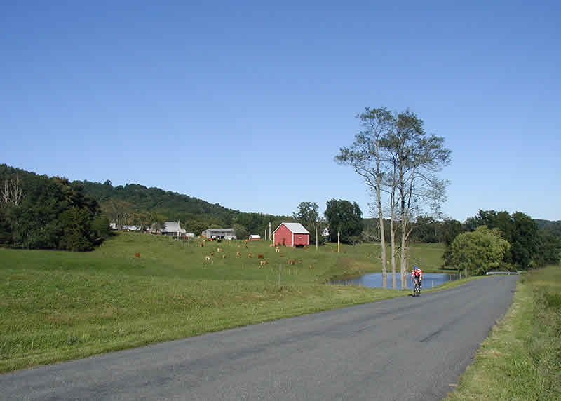
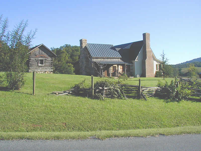
Outside Charlottesville, I don’t think there is another town of more than 10,000 souls in the region, and most of the “bigger” towns are half that size. It’s the very definition of “rural residential,” even more than the hobbit country of west Sonoma County. Check out the pictures I have included with the write-up. Note that I have not included any from up on the Blue Ridge...only shots from down in Madison and Greene Counties. You can find any number of pictures of the Blue Ridge and Shenandoah NP on the internet, but you may not be able to find shots like this of the little roads through the adjoining farmlands.
Down in the valleys, it’s every bit as pretty as the national parks up on the mountains, but it’s a gentler landscape, with more green meadows and grazing cows and horses and more old farms and estates. Some of the country homes are modest and even borderline tract-house in style, and you will occasionally see a delapidated double wide with a dixie flag out front and six junkers on blocks in the yard. But most of the homes are older and handsome and well kept, and a good number are splendid and ancient enough to make one stop and gape: grand old southern mansions in Georgian, Federalist, Antebellum, or Victorian style, plus the occasional, well-preserved log cabin from colonial times. Everything is as green as Ireland, and everything is as tidy as it can be. These folks are mowing fools...they mow everything that grows, and they never stop, probably because if they did, they would soon be overwhelmed by the fecundity of the robust vegetation. Being the local John Deere salesman in this district would make one a wealthy man, for everyone has at least one vehicle for keeping the grass in check, with the result that the rural roadside meadows end up looking almost like golf courses.
And the locals are so friendly! Everyone waved to me as I rode past. Farmers on their tractors wave. Little old ladies getting their mail wave. Even Bubba in his pickup waves. I about wore out my arm waving back. I felt like the Rose Parade queen, waving so much. Our hosts at the inn tell me the local term for waving is “throwing up,” as in throwing up your hand to waggle your fingers at your neighbors. Everybody does it. Drivers are amazingly courteous and patient with cyclists too, at least compared to the yahoos we encounter so often in California. Maybe I was just lucky and missed all the jerks in my brief, 300+ miles of riding. I did get honked at once by a dope in a pickup, but balance that out against having been waved to maybe 100 times over the same period...
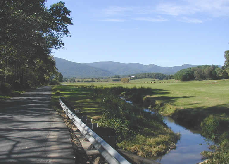 Speaking of our hosts at the inn...[LEFT] I have to put in a plug for the place we stayed (what has become my wife’s home during her months of weekly commutes). Their website calls it the South River Country Inn, while the sign at the foot of their half-mile long driveway says The Farm at South River, but whatever one calls it, it’s a little piece of heaven. It’s a beautifully renovated 19th-century farmhouse set on a hillside in the middle of a 110-acre cattle farm running 100 head of angus beef and a few horses. This and all the adjacent farms are in conservation easements, so everything is pristine and going to stay that way, and all the green pastures run together into a soft, verdant landscape rolling down to the lovely South River and then west to the Blue Ridge, off in the distance. Two ponds near the farmhouse are big enough to support bass and bluegill, snapping turtles and great blue herons.
Cliff and Judy Braun treat their guests like family. If you just want a bowl of Corn Flakes for breakfast, that’s fine. But if you want the royal treatment, Judy will pull out all the stops: eggs fresh from the hen house, raspberry muffins right out of the oven, Belgian waffles swimming in blueberries and maple syrup. You pretty much have to go for a ride after all that carbo loading! In the evening, we would sit out on the front porch of the old farmhouse, tipped back in our rocking chairs, sipping wine and watching the sun drop behind the Blue Ridge. Idyllic is the word.
The inn sits in the middle of this delightful, complex tangle of backroads ideal for cycling, and is only about ten miles from Skyline Drive in the National Park. Plus it’s near tons of other scenic and historic attractions, including the homes of Thomas Jefferson, James Madison, and James Monroe. If you wanted to set up a hub for a week of great rides, you could do a lot worse.
But back to the backroads... One more thing I absolutely loved about the region: the pavement. I claim to be a connoisseur of cycling surfaces, and these roads rate right up at the top of my list. The worst road there would be above average in Sonoma County, and the best roads are smooth as a baby’s bottom. And the quality of the pavement isn’t tied somehow to traffic flow. Some of the tiniest, least used roads had pavement like satin. It makes me wonder how these little counties, with their tiny tax bases, can afford to maintain the roads so well. Or else it makes me wonder why--in comparison--our own county’s roads are so bad. But that’s a rant for another day.
One minor quibble, similar to one already voiced about the ridgeline: down in the valley, there are no major changes in elevation. Nothing is really flat, but nothing is really hilly either. It’s mostly rollers of less than 100’ in elevation. A descent of a minute would be a long one here. So in that sense, it’s a rather tame topography for a cyclist who likes to climb and descend (but probably ideal for a moderate rider). There are the big climbs that connect the valley with the Blue Ridge, but they’re few and far between. Perhaps further exploration of the area would turn up more hills of some substance, but I didn’t find them in any great quantity on my first visit. However, this really is a minor gripe, and if you want the big hills, you only have to go to a little extra trouble to find them.
So... The scenery is terrific, both up on the Blue Ridge and down in the farmlands below; the historic little towns are quaint and picturesque; the traffic is extremely light, except on a few major arterials, and the drivers are polite and patient with cyclists, and everyone is friendly; the pavement is of a dream-like smoothness; they have wonderful seasons... Add in the fact that there is a decent level of sophistication in Charlottesville--good restaurants and shops and a lively arts scene--and the fact that you could sell your California house and buy twice the house and land there and have money left over to invest...What’s not to like?
I keep asking myself that! Aside from the fact that my roots and friends and family are in Northern California and the Pacific Northwest, and that something in me needs a transfusion of Pacific Ocean salt water every couple of weeks, I really don’t know why I couldn’t relocate to this wonderful region. I’m a tireless promoter of the virtues of the North Bay--where I live--as a cycling paradise. I have cycled in many other parts of the world and enjoyed the rides, but I never encountered another region where I could imagine living and cycling full time...until now. I’m not planning on moving to central Virginia any time soon, but I wouldn’t mind going back for a few more days of riding and exploring in the area, and if your own plans turn that way, I highly recommend a bike tour of the region. Just be sure to take in more than simply the famous Blue Ridge Parkway.
Bill can be reached at srccride@sonic.net