September 1, 2009 Tales of the Pacific Crest By: Naomi Bloom |
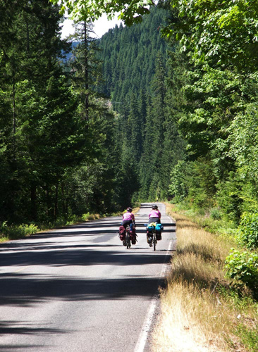
In June, I introduced you to Bil Paul, intrepid cycle tourist and "man in the field" mapping the new Sierra Cascade route for Adventure Cycling Association. Bil became such an expert on the route in the 1980s, when he rode nearly all of the crest along the Sierra Nevada as close as possible to the Pacific Crest Hiking Trail. "Each summer I would take off for a 'nine-day week' of research," he told me, "touring with my biking companion and friend, Patrick Wickman." They covered as much of the crest as possible, heading further south each year. As I mentioned in that column, Bil and Patrick had quite a few adventures. So did Bil on his own charting the new Sierra Cascades route in his Prius last summer. Bil filled me in on a few of those adventures that stood out in his memory. "Patrick was a character. He rode between half and two-thirds of the entire route from Canada to Mexico with me. He was extremely proud of our tours. "We could tour as much as 100 miles per day, including going over a pass or two, me typically carrying 50 or 60 pounds of gear," he recalled. (Remember, Bil emphasized, this was back in the 80s, when he was still in his 40s.) Near Windigo Pass in Oregon, they had to push their bikes through snow and a melted-snow lake. Hard by Mt. Adams and Mt. St. Helens in Washington, they were forced to ride/push the bikes through miles of freshly laid gravel. "One time when we were biking near the Columbia River," Bil remembered, "Patrick yelled behind me that he'd been shot. I beat my way back and he was rubbing a spot on his back. Turns out one of his bungee cords had broken, snapped back, and the hook hit him hard." Most of the route Bil charted back then used lesser-traveled paved roads, with a few unpaved roads. Often, when his choice was unpaved, he offered a paved alternative, especially if the unpaved road went into a remote area with few amenities. "I remember one time when I was riding alone in the canyon of the North Fork of the King's River," Bil wrote me. It was a "really remote and beautiful area with no stores, no piped water, and only primitive campgrounds. One morning I headed up a long dirt road (blocked to vehicle traffic) toward Kings Canyon National Park, with little water and not much food, and in the high heat of the day. I had to get off my bike and push it. Between the bugs trying to get in my eyes and ears and running out of water, I began to get quite lightheaded. I knew I had to get water or suffer the consequences. I finally ran into a creek crossing the road, but cattle had walked and had wallowed in it. I took every article of clothing I had with me and layered them all together and filtered the stream water through all of that. And drank it. "When I made it up to the top, and the paved road, I found a pickup with a cowboy in it who gave me a beer. For the rest of my life, I will never have another beer that will taste quite as good. When I got to the campground that evening I drank a half gallon of apple juice."
Flash forward to 2008Last year, driving the Prius in the mountains north of Los Angeles along Highway 2 not far from Big Pines, Bil's planned route was blocked by construction. "I had to drive several hundred miles out of my way to get to the other side to continue the research.A couple days to the north, in camp, he tossed his ham radio antenna wire up into a tree using a wrench for a weight. When it bounced back, it hit the Prius windshield and broke it. Rising the next morning, he hoped that " was just a bad dream." But nope, all those cracks were still there. "That little Prius, with not a lot of clearance underneath, powered along some pretty rough dirt roads. I really had to drive gingerly to avoid big rocks and the like. There was one place, just to the north of Crater Lake National Park, where I researched an unpaved-road alternative road over Windigo Pass to Crescent Lake (the one and the same pass where Patrick and I ran into snow and meltwater years ago) and the car toughed its way through, broken windshield and all." Near McCloud, not far from Mt. Lassen National Park, Bil ran into a family down on their luck, stranded along the road. "I stopped and asked if I could help. They needed some transmission fluid, so I drove on into town, got what they needed, and returned." When Bil crossed the Oregon-Washington border at f Hood River, he felt he could finally could see the light at the end of the tunnel, so to speak. The side roads he was checking out in the Yakima area and Methow Valley were panning out and usable. When at last he rolled into the economically distressed town of Sumas at the Canadian border, he could celebrate the end of the main route. He took a few pictures of the border checkpoint and had a few beers and a fine meal. "I was taken aback by the outdoor sign next to a Sumas church," he remembers. "It read: 'Feeling lost? My book is your map. -- God.' Sometimes the way things happen seems almost surreal." There is one final story to tell, Bil emailed me later. "Camping in a campground along the Truckee River northwest of Lake Tahoe, I ventured over to the next campsite to talk to the couple there. Turns out they were from Dixon. Their stories about the town so intrigued me that one thing led to another, and when a year later my wife Lorraine and I were looking around for a retirement home to buy, we settled on Dixon." They moved in earlier this year. In fact, they were still unpacking while Bil was plying me with his tales. "I really have to thank Lorraine for helping me with this trip," he wrote, "and putting up with my being away for so long. She was very supportive. Also for watering my veggie garden while I was gone É ." It's doubtful that Dixon will hold Bil down for long. As I reported in June, he's planning more adventures -- one along the Great Divide Route, and yet another California route connecting all the historic Spanish missions. No more backwoods then, huh Bil? Let me tell you about the traffic near Mission Dolores in San Francisco. Or the "tank crossings" surrounding Mission San Antonio in Hunter-Liggett military reserve. Happy trails! |
|
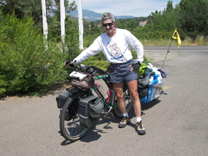 "At that early period in his touring career, he rode without a shirt and seemed to live off peanut butter and jelly sandwiches. He wasn't always so happy that I stopped so frequently to take notes and pictures."