 Must Do Climbs
by: John Summerson 12/15/2010
10%
A grade that reaches 8% can seem difficult at times. The bike first notices the slope and soon communicates the message that something has changed. Your pleasant ride is over for the day and effort and concentration must respond in kind. At the point when the roadway reaches 10%, particularly for extended stretches, riding gets down to serious business. While only slightly steeper, at this grade the mind can also come into play, at times producing a bit of nagging doubt about the outcome and you may begin to imagine there are other gears available to ease your suffering.
Even some legendary climbs contain little pitch of this magnitude. The Galibier and the Tourmalet, Tour de France regulars and considered among the most difficult hills used in that storied race, and others such as Colorado’s giant Mount Evans, contain very little grade that reaches 10%, much less extended climbing at that severe slope. In my mind 10% represents a tipping point for road gradients as the ride goes from simply challenging to downright painful and a true struggle to reach the top.
Californians have the greatest assortment of road bike climbs to choose from in the entire country. From beyond category monsters in the Sierra Nevada Mountains to more moderate climbs along the coast and the shorter but generally steeper ascents in the Bay Area there are multiple rewarding climbs for all types of riders. The following climbs, one in each of four regions of the Golden State, all have a large percentage of their route over 10%+ grade. Regarding the rating listed; in major races climbs are typically rated numerically 1-4 dependent upon their length and grade with 4 as the least difficult classification. A hill considered more difficult than category 1 is described as hors or a beyond category climb.
Northern California
Fort Ross Road
Total elevation - 1,367 ft - Length - 2.4 miles
Average grade - 10.8% (16%) - Rating - 1.47 (cat 1/2)
Isolated Fort Ross Road is a steep and scenic test that begins on the picturesque Pacific Coast Highway north of Bodega Bay. You get short stretches of shallow climbing at the beginning and end of the climb but the middle core is double digit grade and will make you work (over half of the hill is > 10%). This section is along a narrow and dark road for the most part under thick stands of trees. Due to its steep grade it is a difficult descent as well. This climb leads to other outstanding riding (and climbing).
Crux stretch - The middle 1.5 miles will wear you down.
Directions - From Bodega Bay on Route 1 head north along the spectacular coast for ~22 miles to Fort Ross Road on your right where the climb begins.
Central California
Sonora Pass West
Total elevation - 3,354 ft - Length - 9.1 miles
Average grade - 7.0% (21%) - Rating - 3.00 (hors/cat 1)
This is a tough and scenic climb that heads east on Route 108 through the rugged Sierras. The steepest section comes almost immediately and the first few miles are along double digit grade. The rest of the climb is variable with steep sections interspersed with several small descents. In fact almost 3 miles of the route is over double digit grade. The final few miles ease a bit as you approach the summit but the entire route is very scenic. This is one of the great American climbs (closed in winter - Stanislaus National Forest - 209 532-3671).
Crux stretch - You must be ready early on this climb as the 2nd half of the first mile is crucial as it is steep all the way and contains a short section of 20%+ grade.
Directions - From Sonora, CA take Route 108 east for ~50 miles to Dardanelle. Several miles beyond, Kennedy Meadows Campground appears (right) where the climb begins just beyond the warning sign.
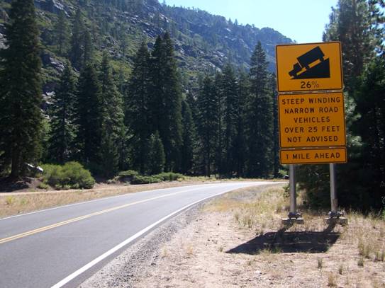
Steep grade ahead toward Sonora Pass
Southern California
Tramway Road
Total elevation - 1,910 ft - Length - 3.8 miles
Average grade - 9.5% (14%) - Rating - 1.82 (cat 1)
Tramway is a very steep and dramatic test along the road to the Mount San Jacinto State Park cable car near Palm Springs. The route begins as gentle but this is only break you will get on this hill as the grade soon reaches 10%+ and stays there for the majority of the climb. You get short breaks at a few spots and the last mile is the steepest. The scenery can help get you to the top and the max grade greets you over the last 25 yards. Very hot in summer, the descent is a burner as well.
Crux stretch - The final mile which is the steepest of the climb and contains the max grade of the ascent.
Directions - In Palm Springs head to the junction of Route 111 and Tramway on the NW side of the city where the climb begins at that junction.
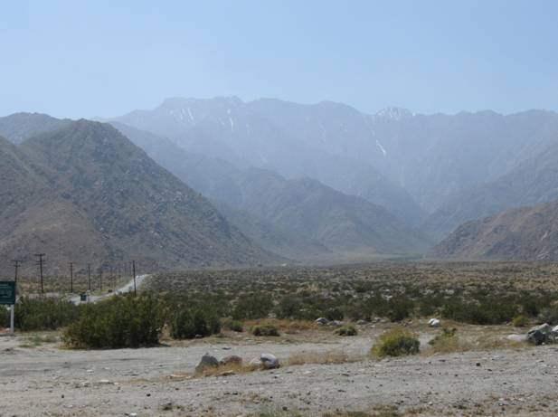
Great Views looking up Tramway Road
Bay Area
Alba Road
Total elevation - 2,030 ft - Length - 3.8 miles
Average grade - 10.2% (18%) - Rating - 2.14 (cat 1)
Alba Road is a very steep and scenic climb through stands of big redwoods along a variable grade south of San Francisco. The grade is variable in that it is either steep or steeper for the most part. In fact over two miles of its fairly short route is 10% or greater. The grade finally eases only at the very top and the ascent ends at Empire Grade. The whole climb is the crux stretch as it contains double digit grade throughout. Another thing that sets this climb apart is its dark route among the redwoods. Due to its steep grade and dark nature it is a difficult and wild descent.
Directions - From Santa Cruz, CA take Route 9 north to the small town of Ben Lomand. Alba Road takes off to the left in the middle of town.
John can be reached at jsummers@wfubmc.edu