 Must Do Climbs
by: John Summerson 11/15/2010
Most Scenic Descents
One of the best reasons to get on a bike is one we often do not think much about. As there is no roof over your head or windshield in front of you, there is really nothing in your way to spoil the view. Particularly in California riders can be treated to a wide variety of quite impressive scenes as they pedal along. From the coast to the mountains cyclists here can experience almost every landscape on earth. Typically however, it is over hilly terrain that the best views emerge, if you can lift your head to take in the view.
Californians have the greatest assortment of road bike climbs to choose from in the entire country. From beyond category monsters in the Sierra Nevada Mountains to more moderate hills along the coast and the shorter but generally steeper ascents in the Bay Area there are multiple rewarding climbs for all types of riders. The following hills, one in each of four regions of the Golden State, are all among the most scenic in those regions. Regarding the rating listed; in major races climbs are rated numerically 1-4 dependent upon their length and grade with 4 as the least difficult classification. A hill considered more difficult than category 1 is described as hors or beyond category.
Northern California
Mount Shasta
Total elevation - 4,192 ft - Length - 14.5 miles
Average grade - 5.5% (9%) - Rating - 2.57 (cat 1)
The ascent of Mount Shasta is a scenic ride and is perhaps the most difficult in northern California. From the starting point, the road immediately begins to climb up the southwest flank of the mountain. After just less than a mile, turn left on Everett Memorial Hwy (A10). In several more miles you enter a pine forest which you glide in and out of all the way to the top. The climb is smooth and steady with no steep pitches but the over 4,000 vertical feet of climbing make this a workout. The road opens up at the top into several small parking areas with great views. This hill is almost identical regarding length and grade to the Courcheval, a tough climb that is often used in the Tour de France. It is a very fast descent as well (last 2 miles closed in winter - Shasta-Trinity National Forest - 530 926-4511).
Directions - From Mount Shasta, CA on I-5 exit east into town and then turn left on Mount Shasta Blvd. Go north on this road until you are almost out of town, and then turn right on Ski Village Rd. The climb begins at the intersection of Mount Shasta Blvd and Ski Village Rd.
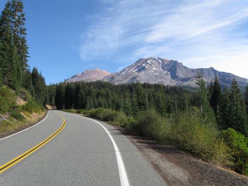
Mount Shasta
Southern California
Glendora Mountain Road North
Total elevation - 1,615 ft - Length - 6.4 miles
Average grade - 4.8% (8%) - Rating - 0.78 (cat 2)
One of the most scenic climbs in the state, the north side of Glendora Mountain Road starts along a river and then makes a 180 degree turn. At that point the route clings to a ridgeline with spectacular views of the San Gabriel Mountains. Not a difficult ascent, the listed climb ends at the stop sign near the top of the ridge.
Directions - In Azuza, CA take Route 39 north into the mountains to the reservoir. At the reservoir turn right on East Fork Road and travel ~4 miles (rolling) to where the road crosses the drainage over a high bridge. The listed climb begins here.
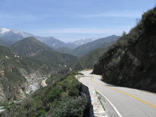
The north side of Glendora Mountain Road near LA
Central California
Nacimiento Fergusson Road West
Total elevation - 2,506 ft - Length - 6.9 miles
Average grade - 6.9% (11%) - Rating - 1.74 (cat 1)
Its length matching its average grade, the west side of Nacimiento Fergusson Road is a solid climb that is perhaps the most scenic in the United States. Its start is a bit isolated but the views of the Pacific Ocean as you ride certainly make any inconvenience to get there worthwhile. It is over a variable grade and very narrow without any shoulder over much of its length. It is a difficult descent as well. The east side of this hill, while not a tough climb, is single lane in places and winds through a tunnel of trees with access through a military installation.
Directions - From San Luis Obispo, CA head north on Highway 1. Nacimiento Fergusson Road is on your right about halfway between San Simeon and Big Sur. The climb begins at its junction with Highway 1
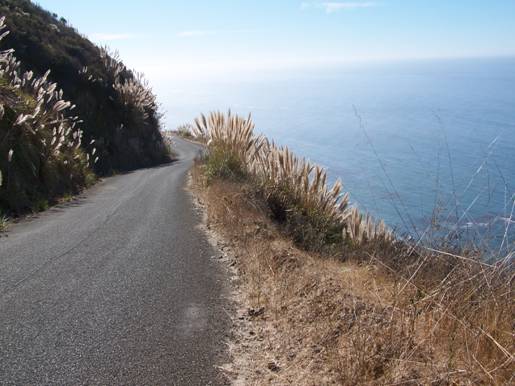
Spectacular Nacimiento Fergusson Road
Bay Area
Alpine Road West
Total elevation - 1,865 - Length - 6.4 miles
Average grade - 5.5% (10%) - Rating - 1.03 (cat 1/2)
The west side of Alpine Road is a classic ascent, passing through thick stands of redwoods down low and offering great views up top when the trees thin. A shallow start soon leads to more variable grade. Around mile 4 and right after a section of stout grade, you break out of the trees and pass the turn for Portolo State Park. Keep riding uphill into the upper climb. This section is quite variable and with long views. The listed climb ends ~ 1 mile short of its junction with Skyline with its multiple riding/climbing options.
Directions - In La Honda on Route 84 head south on Pescadero Road for just over a mile and Alpine Road will appear on your left where the climb begins.
John can be reached at jsummers@wfubmc.edu