 Must Do Climbs
by: John Summerson 10/15/2010
For The Sake Of Speed
We all ride for difference reasons. Many get on the bike for exercise or to simply get outside and enjoy the scenery. Others are in the saddle for more competitive reasons; perhaps racing or looking to challenge themselves in a physical way. Most riders will agree however that what is likely the most excitement you can have on the bike is the feeling you get on a long and fast descent; one that brings out the goose bumps as you fly along. With enough grade to generate sufficient speed and without too many tight turns you find yourself flowing down the hill and actually having fun on the bike. It can be a learning experience as well, perhaps by choosing to push your speed to your limits (and still finishing the descent in one piece).
Californians have the greatest assortment of road bike climbs to choose from in the entire country. From beyond category monsters in the Sierra Nevada Mountains to more moderate hills along the coast and the shorter but generally steeper ascents in the Bay Area there are multiple rewarding climbs for all types of riders. The following hills, one in each of four regions of the Golden State, are all among the quickest descents in those regions. Regarding the rating listed; in major races climbs are rated numerically 1-4 dependent upon their length and grade with 4 as the least difficult classification. A hill considered more difficult than category 1 is described as hors or a beyond category climb.
Northern California
Forest Mountain Summit West
Total elevation - 1,154 ft - Length - 3.4 miles
Average grade - 6.4% (9%) - Rating - 0.76 (cat 2)
The west side of Forest Mountain Summit is a short but sweet climb along Route 3 in far north California. The road carries traffic from the Scotts Valley over to Yreka on Interstate 5. The road is straight and steady grade which results in a rocket descent down to Moffat Creek. There is a bit of traffic on this road most days but not enough to ruin a ride. The east side of Forest Mountain Summit is a similar hill although just a bit less steep and more twisty.
Directions - On Route 3 in tiny Fort Jones head east for ~8 miles to Moffat Creek where the climb begins by continuing east on Route 3.
Central California
Lake Sabrina
Total elevation - 4,734 ft - Length - 15.6 miles
Average grade - 5.8% (10%) - Rating - 3.15 (hors/cat 1)
Fairly shallow over the first two miles, the grade on the climb of Lake Sabrina soon increases through a big switchback. Once past there are big views of the Sierra Nevada Mountains. After passing the South Lake junction the steepest section appears and the road heads toward a very spectacular alpine upper end; turning to one-lane before ending just above the lake at a small parking area. Its descent is a burner, only really broken up a bit by the big switchback toward the bottom. Once past, you can once again return to high speed.
Directions - From Route 395 in Bishop, CA in Owens Valley, take 168 (Line Road) west for 3.2 miles to its intersection with Red Hill Road (on the right) where the climb begins.
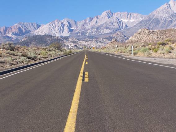
The long finishing straight on Lake Sabrina
Southern California
18 South
Total elevation - 4,214 ft - Length - 14.0 miles
Average grade - 5.7% (9%) - Rating - 2.50 (cat 1)
18 South carries a lot of traffic and is four lanes most of the way up with the first half of the route carrying the steepest grade. There are good views near the top and the climb ends in the small community of Crest Forest. You can shorten the hill by 0.9 miles by using steep and 2 lane Old Waterman Road which parallels 18 part of its way up the mountain. At the top turn around and enjoy your way down. The wide road and mostly gentle curves help create a great descent and the solid grade produces speed. The only downside to this route is the traffic and it will keep you on your toes at times.
Directions - From I-10 in San Bernardino take route 18 (Waterman Ave) north for 4-5 miles to its intersection with 48th Street (left) where the listed climb begins.
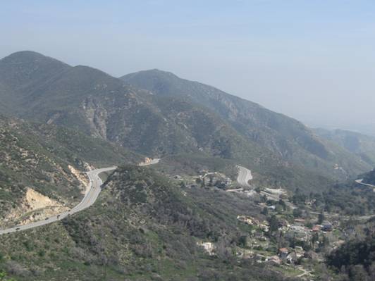
The steady grade and views on Route 18 South in SoCal
Bay Area
Empire Grade
Total elevation - 1,512 ft - Length - 9.1 miles
Average grade - 3.2% (12%) - Rating - 0.48 (cat 2/3)
This is long climb from near sea level out of Santa Cruz that does carry some traffic at times. It has a variable grade and one steep section. The listed end is its junction with Felton Empire Road although Empire Grade continues to climb in a rolling manner for a few more miles. The roads in the Bay Area are rarely straight so long descents that can create a swift pace are somewhat rare. This one is a bit twisty up top but soon begins to produce some speed. Its descent has been used by the professionals in the Tour of California so enjoy.
Directions - From Highway 1 In Santa Cruz take King Street north for 0.2 miles and turn right on Story Street. Travel Story until it dead ends at High Street. Turn left on High Street to begin the climb which soon becomes Empire Grade.
John can be reached at jsummers@wfubmc.edu