 Must Do Climbs
by: John Summerson 8/15/2010
Everest Challenge
Big Mountain Climbing
Mount Everest is 29,035 feet above sea level. A notable number no doubt, easy to recall as it denotes the highest point on earth. There are no paved roads anywhere near the mountain of course, adding to the challenge of getting to its summit. As many cyclists are typically looking for a challenge, intrepid riders came up with a race that requires that amount of climbing over two days. Aptly named the Everest Challenge, it is the most difficult race in the United States with over 29,000 feet of vertical gain over its route.
The two day event takes place each September in Owens Valley and there are few areas in the state of California so dramatic. This is big mountain climbing at altitude and all of the six ascents included in the 2010 event are among the most difficult, not only in California, but the entire US. In fact 4 of the climbs in this year’s race are rated as hors or beyond category climbs.
A colleague once spoke to three time Tour de France winner Greg Lemond while riding in these mountains. Approaching him as he was resting with others near Highway 395 during a ride he noted it was nice to be among greatness, referring to Lemond as one of America’s greatest cyclists. Lemond reportedly nodded toward the giant eastern wall of the Sierra Nevada Mountains and said “…no, that is true greatness”. They were both right.
The race draws a moderately sized field each year and contains a variety of cyclists from casual amateurs to cat 1 riders. With high season here all of these ascents are open so if you are not registered for the event try to get to one or more of these climbs this year before snow closes them out. Just keep in mind these are difficult climbs in somewhat isolated terrain so go prepared. For more information on the event go to www.everestchallenge.com.
Californians have the greatest assortment of road bike climbs to choose from in the entire country. From beyond category monsters in the Sierra Madre Mountains to more moderate climbs along the coast and the shorter but generally steeper ascents in the Bay Area, there are multiple rewarding climbs for all types of riders. The following climbs, each included in the 2010 Everest Challenge and listed in race order, are all challenging and should be considered must do ascents for those looking to go seriously uphill on the bike. Regarding the rating listed; in major races climbs are rated numerically 1-4 dependent upon their length and grade with 4 as the least difficult classification. A hill considered more difficult than category 1 is described as hors or a beyond category climb.
Rock Creek Road
Total elevation - 5,548 ft - Length - 20.5 miles
Average grade - 5.1% (9%) - Rating - 3.38 (hors/cat 1)
Start on very scenic Lower Rock Creek Road through one major descent and then resume climbing up to four lane Route 395. At the junction with 395 continue to climb north on that road (watch the speedy traffic) for 0.9 miles and turn left on Rock Creek Road at Toms Place. This section is fairly shallow to start but the grade soon increases as you ascend through a twisty canyon. Near the top snow capped peaks appear and this route ends as the highest paved road in California (closed in winter - Inyo National Forest - 760 876-6222).
Directions - From Bishop, CA head north on Route 395 for ~8 miles to its junction with Pine Creek Road (left). Lower Rock Creek Road takes off on the right almost immediately after you turn onto to Pine Creek Road. Follow Lower Rock Creek Road for 3.6 miles to the Inyo County line (Boundary Road on left) where the listed climb begins by continuing on Lower Rock Creek Road.
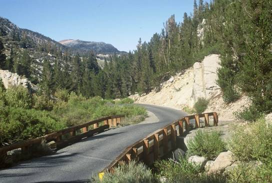
Single lane on upper Rock Creek Road
Pine Creek Road
Total elevation - 3,075 ft - Length - 8.7 miles
Average grade - 6.7%
(10%) - Rating - 2.29 (cat 1)
This is a stout climb along a creek within a steep-walled canyon. Like almost all climbs of the eastern Sierra, the route gets steeper you ride. Eventually a twisting road along a steady grade makes for a pleasant ascent. Very scenic in its upper end, the last 0.8 mile is along a private, narrow road up to a mine.
Directions - From Bishop, CA head north on Route 395 for ~8 miles to its junction with Pine Creek Road on the left. Head down Pine Creek Road for 1.6 miles to begin the listed climb.
South Lake
Total elevation - 5,445 ft - Length - 18.8 miles
Average grade - 5.5% (14%) - Rating - 3.52 (hors/cat 1)
South Lake, also called Bishop Creek, is quite intimidating at its start as you can clearly see where you are heading. The route is shallow at first but gradually gets steeper as you ride. A big switchback a few miles in will get you warmed up. At mile 11.6 turn left toward South Lake. After a small dip and then several miles of shallow grade there are steep sections with grades running from 10-14% as you approach the top. The scenery is amazing however as the climb mercifully ends just above the stunning namesake lake at the end of the upper parking lot just shy of 10,000 feet (top section closed in winter - Inyo National Forest - 760 876-6222).
Crux stretch - The final half mile which contains double digit grade.
Directions - From Route 395 in Bishop, CA take 168 (Line Road) west for 3.2 miles to its intersection with Red Hill Road (on the right) where the climb begins.
Glacier Lodge Road
Total elevation - 3,747 ft - Length - 9.8 miles
Average grade - 7.2% (10%) - Rating - 3.02 (hors/cat 1)
Glacier Lodge Road is a very difficult climb beginning in Big Pine, CA that leads into the high Sierras. It carries a steep grade almost all the way up to a scenic alpine setting (the lodge is no longer there). A big switchback approximately half way up will get your attention and the grade finally eases near the top. The climb ends at a small parking area with great hiking possibilities. This is an extremely fast descent so watch the drop off into the creek and the cattle guard on the way down. This climb is almost identical in length and average grade to the mighty Tour de France climb of the Tourmalet (closed in winter - Inyo National Forest - 760 876-6222).
Crux stretch - The 4.5 mile stretch that begins at the big switchback 3 miles into the climb.
Directions - From Route 395 in Big Pine, CA head west on Crocker Street for 0.6 miles where the climb begins (unmarked start).
High on Glacier Lodge Road
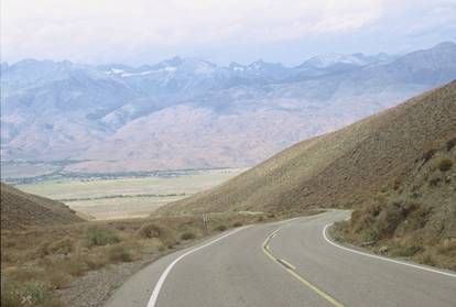
Death Valley Road West
Total elevation - 3,722 ft - Length - 13.8 miles
Average grade - 5.1% (9%) - Rating - 2.11 (cat 1)
The west side of Death Valley Road is a solid climb with almost no traffic. The first few miles are shallow and then the grade increases as you ascend the mountain. You break out with views near the top and the climb ends at an unmarked but obvious summit.
Directions - In Big Pine, CA head east on 168 for 2.2 miles to the junction of Death Valley Road on the right where the climb begins.
The beginning of the west side of Death Valley Road
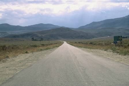
White Mountain
Total elevation - 6,204 ft - Length - 20.1 miles
Average grade - 5.9% (11%) - Rating - 4.31 (hors)
This is a great ride and climb toward White Mountain out of massive Owens Valley and the most difficult used in the 2010 Everest Challenge. The first section is fairly shallow. Soon the grade increases and along a steep ramp the road passes through a unique one-lane section with blind corners. The grade then flattens out and you turn left on White Mountain Road at mile 12.7. After another somewhat shallow section the grade slowly increases and the road begins to roll up and down as you ascend. The last few miles are steep and at high elevation which may test some riders but the finishing stretch along a ridgeline offer great views of Owens Valley and the Sierras beyond. The hill crests at over 10,000 ft just before the pavement ends (upper half closed in winter - Inyo National Forest - 760 876-6222). A rough dirt road continues for quite a few miles to White Mountain. This is a long and tough climb so make sure you are prepared.
Crux stretch - The final mile is key.
Directions - In Big Pine, CA head east on Route 168 for 2.2 miles to the junction with Death Valley Road (on the right). The climb begins from there by continuing east on 168.
John can be reached at jsummers@wfubmc.edu