 Must Do Climbs
by: John Summerson 3/15/2010
Must Do Climbs - Part 1
Climbing may be the most difficult and intriguing aspect of cycling. It can be about pain and perseverance as well as planning and persistence. However one describes the process, for most cyclists it is a worthwhile feat that leads to a sense of accomplishment. Just standing on a challenging climb’s slopes generates excitement and a bit of fear as you anticipate its difficulties. In addition, famous climbing exploits among professional riders often become the stuff of legend. Success for most however involves simply getting to the top of the hill.
Californians have the greatest assortment of road bike climbs to choose from in the entire country. From beyond category monsters in the Sierra Madre Mountains to more moderate climbs along the coast and the shorter but generally steeper ascents in the Bay Area there are multiple rewarding climbs for all types of riders. The following climbs, one in each of four regions of the Golden State, are all challenging and should be considered must do ascents for those looking to go seriously uphill on the bike. Regarding the rating listed; in major races climbs are rated numerically 1-4 dependent upon their length and grade with 4 as the least difficult classification. A hill considered more difficult than category 1 is described as hors (French) or a beyond category climb.
Northern California
Pine Flat Road
Total elevation - 2,924 ft | Length - 11.4 miles
Average grade - 4.9% (20%) | Rating - category 1/2
Pine Flat Road is a unique road that winds through a wildlife area and dead ends at the top of a ridge. It is wide single lane the entire climb and contains good views in places and several long flats/descents. The work on this one is in its upper end over a steep final mile that includes a short stretch of 20% grade. The listed climb ends just before a locked gate. Traffic is very light on this road which makes for a pleasant ascent.
Directions - From Healdsburg, CA (on 101 just north of Santa Rosa) take Healdsburg Ave north for a short distance to Alexander Valley Road on the right. Travelling east on this road you soon cross Route 128 (keep straight) and the road becomes Pine Flat Road. The listed climb begins ~0.7 miles from that junction (road goes to single lane) by continuing on Pine Flat Road.Central California
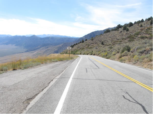
Views from the east side of Monitor Pass
Monitor Pass East
Total elevation - 3,216 ft | Length - 9.5 miles
Average grade - 6.4% (10%) | Rating - category 1
Monitor Pass East is a tough climb that rises out of the high desert near the Nevada border. A more difficult ascent than its western side, the grade is fairly steady and eases only over the last few miles to finish at 8,314 ft. Hot in summer as it is exposed over its entire length, the east side of Monitor is also a fast and fun descent (closed in winter - Stanislaus National Forest 209 532-3671).
Crux Stretch - The half mile that ends at the Alpine County line which is the steepest section of the climb.
Directions - From Gardnerville, NV take 395 south for approximately 35 miles to Route 89 (right), passing into CA along the way. The climb begins at the intersection of Routes 89 and 395 by heading west on 89.
Southern California
Sulphur Mountain Road
Total elevation - 1,208 ft | Length - 2.8 miles
Average grade - 8.2% (10%) | Rating - category 2
Sulphur Mountain Road is a very elegant ascent located between Santa Barbara and Los Angeles. A wide single lane gives the climb a European look and a steep grade will make you work. Up top thick trees provide a tunnel like ride with good views when the trees thin. The listed climb ends at a driveway on the left (gated) just before a Doppler radar tower. After the unmarked top the road rolls up and down before turning to dirt. This is a must do climb in the area.
Directions - In Ojai, CA head east on Route 150 for 6-8 miles and Sulphur Mountain Road will be on your right. Head down the road for 0.3 miles to begin the climb.
Bay Area
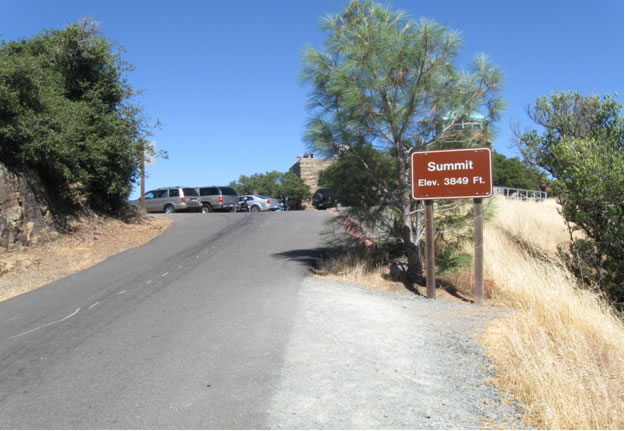
The very top of Mount Diablo near Danville, CA
Mount Diablo South
Total elevation - 3,169 ft | Length - 10.4 miles
Average grade - 5.8% (17%) | Rating - category 1
The southern side of Mount Diablo is one of the most popular ascents in the Bay area. A twisty route reveals good views in places. The grade is fairly steady and it is exposed over much of its length. At mile 6.0 bear right to continue uphill. Just before the end you encounter a short double digit grade section that gets you to the very top (dead end) with great views on clear days. Its descent is challenging and you will likely have a bit of company (cars and riders) on this ride as well.
Directions - From Interstate 680 in Danville, CA head east on Diablo Road through several turns for 3.1 miles where you turn left toward Mount Diablo State Park (signed). The listed climb begins at a dip in the road 0.5 miles after you make the left turn.
John can be reached at jsummers@wfubmc.edu