
 On The Road
by: Bill Oetinger 9/1/2003
Inyo Face
In March, 2002, I wrote an article in this space about some of the big climbs in the Italian Alps, comparing them to some of our domestic ascents (domestic in my case being Sonoma County, California). You can revisit that article at Who’s Afraid of the Big, Bad Hills?.
The biggest difference between them is something that could probably best be termed “scale.” In a few cases, the big Euro-climbs are steeper than our local hills, but the real difference is overall size: they just go on and on and on...often ten miles long and sometimes over twice that distance...most of the time at a fairly respectable gradient. (A long climb for us locally is around five miles.) The conclusion I came to was that the climbs of California’s coastal mountains--as wicked as they can be--simply do not measure up to those epic ascents of the Alps.
Recently though, I have explored some California climbs that do measure up, and I think I can safely say that if you want to get a true sense of what the big climbs are like that you see the pros chugging up in the Giro and Tour and Vuelta, you can find out without flying to the continent. All you have to do is drive to the eastern flank of the Sierra Nevada, over along Hwy 395. There, from just south of Lone Pine to just north of Bishop, you can climb to your heart’s content, or more probably until you feel like coughing your heart up and leaving it beating feebly on the side of the road.
So, in the interest of broadening your horizons, I am going to present a brief summary of these monster climbs, working from south to north...
Horseshoe Meadows
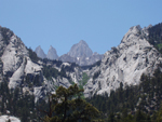
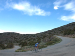
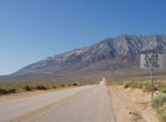 The title of this column--Inyo Face--comes from the fact that almost all of these climbs are up the eastern face of the Sierra mountain range in Inyo county. But it works as a pun too, especially in the case of this huge climb. If you look up from Lone Pine at the looming front rank of mountains above the town, you can’t help but notice the Horseshoe Meadows road carved into the cliff face, far above. There are five great, switch backing traverses working their way up the wall. It is one of the most impressive and intimidating looking climbs around, and once you see it from the bottom, you will think about it and dream about it until you have a chance to do it. If there is one saving grace in this mind-messing climb, it’s that each successive leg of the switchbacks is shorter than the one preceding it, like traversing across the face of a pyramid.
The town of Lone Pine sits at 3700' and is the launching pad for both this climb and the famous Whitney Portal climb. The Horseshoe Meadows summit is just below 10,000', plus there is a descent of around 350' near the top of the hill, bringing the total elevation gain to over 6000' in around 25 miles. I don’t think the grade ever exceeds 10% on this big boy, but it stays in the 8% range for long stretches. Those numbers compare favorably with most of the famous climbs in the Alps.
You can take Horseshoe Meadows Road right from its junction with Whitney Portal Road, three miles uphill from Lone Pine. But I recommend taking Tuttle Creek Road out of town and wandering around in a region known as the Alabama Hills on the way up to the big climb. The Alabama Hills are not to be missed. They are a jumbled pile of wildly contorted standing stones and boulders, caves and canyons covering an area maybe 15 miles long (north to south) and five miles wide, all just west of Lone Pine. It’s an anomalous geological formation that bears little resemblance to the nearby Sierra, and it’s one of the most fantastic landscapes you’ll ever see...a wild and crazy place.
 It also happens to be replete with history, as it has been the shooting backdrop for literally hundreds of movies and westerns, from legendary films such as Gunga Din, Bad Day at Black Rock, and High Sierra to the many, many western serials of Roy Rogers, Hoppalong Cassidy, and the Lone Ranger. Tuttle Creek winds through this fantasyland and gives you a great exposure to all its amazing rock sculptures, then delivers you to the main road up the mountain. I suggest you take the main road on the way back, all the way to Whitney Portal Road. The scenery is good going that way too, and you end up with less of an out-&-back.
Locals tell me Horseshoe Meadows Road was paved in three sections over three consecutive summers by three different contractors. And from the looks of it, following three different sets of paving specs. The paving ranges from decent to deplorable, with large sections in chip seal that more accurately might be called chunk seal, as the aggregate is extremely coarse and abrasive...not a problem on the climb, but rather tiresome on the descent.
What you see in the first photo--the five big switchback traverses--represents the lion’s share of the climb. Where the road tips over the crest, you get the 350' descent--which turns into a climb on the way back--and then another few miles of moderate climbing to the road’s end. The end of the road is a bit anticlimactic: just a parking lot and trailhead leading up into even higher country...all pretty, but nothing extraordinary. The real scenic payoff is at the top of the last switchback, where there are panoramic views back down to the Owens Valley, most of 6000' below...a huge vista.
 The photo is misleading in one other sense as well: the traverses are cut at such an even gradient across the cliff face, it appears from below as if each section is a straight run of road. Not so: the road bends out and around an endless number of rock buttresses, so that the traverses are actually made up of many sinuous S-bends...hardly a straight stretch to be seen, except at the bottom, where the road cuts across the alluvial fan. (We’ll have more to say about alluvial fans later.) The many slinky bends make the descent a lot more interesting than you might expect it to be, and if the pavement were better, it would be off-the-chart fantastic. Even with the slightly abrasive surface, it’s still a wild run.
Whitney Portal
Even folks unacquainted with this region will have heard of Whitney Portal. It is the gateway to Mt Whitney, at 14,494', the highest peak in the lower 48. It is justly famed not only for its incredible scenery, but also as an epic cycling challenge. Beginning in 3700' Lone Pine, the road climbs to the 8371' trailhead over 12 miles, and the grades reach a leg-breaking 15%, carrying on at that pitch for way longer than you would want. Total climb is “only” 4700', but I rank this as one of the hardest of the climbs I did among this tour of mega-monsters.
It is possible to combine the Horseshoe Meadows climb and the Whitney Portal climb into one, big stage. You would end up with a day of over 70 miles and over 10,000' of gain, much of it at high altitude....a very butch ride. When I toured here in June, it was over 100° every day, and although it does cool down at the higher elevations, you have to climb through the heat to get there. On the day I did Horseshoe, it was 114° when I got back down to the junction with the Whitney road. That made it easy to decide to do the second climb the next morning, rather than in the heat of the afternoon.
I liked the Tuttle Creek meander through the Alabama Hills so much, I did it a second time on the way up the Whitney climb. It was a bit out of the way, and it turned the 12-mile climb into a 15-miler, with a slight downhill run in the middle, bringing the total climb to a nice tidy 5000'.
 Once on the main climb, you have to deal with the alluvial fan. What is an alluvial fan? It is that region at the base of the steep mountainsides where, over millions of years, all the little rocks that have tumbled off the big cliffs have fanned out into broad slopes of slightly compacted scree...gravity at work, on a grand scale. Almost every one of these big Sierra climbs begins with a run across an alluvial fan. They are invariably exposed expanses of rock, with very little vegetation above head height...no shade and lots of heat. They are uniformly boring and frustrating and wearying for a cyclist: they seem to go on interminably, at whatever gradient the road engineers deemed tolerable for car travel...anywhere from 4% to over 10%. I came to detest alluvial fans heartily by the time I was done with this week of climbs. Once you’re up into the mountain forests and steep cliffs, with little streams and grand vistas, things are very entertaining. Out on the fans, you just suffer and wilt and whine, churning away at the pedals but never seeming to go anywhere.
Whitney Portal’s alluvial fan is as bad as any of them, and it culminates with an extremely discouraging section that is almost ruler straight for two or three miles and quite steep...9% or more. Once you get to the end of that never-ending chute, you are finally at the base of the real granite mountains, where the switchbacks begin to climb up the cliff face. That’s the good news: the alluvial fan is behind you and the scenery gets better. The bad news is the road tilts up to a gnarly 15% just as it claws onto the granite.
I’m a little fuzzy on the miles here, but I would guess you’re about four miles below the summit at this point. You make one long traverse to the north, another equally long and steep one back to the south, and then you round a corner and point straight back into the deep gorge that leads up to the trailhead. The views down into the valley are spectacular, but they are nothing compared to the view up the canyon to magnificent Mt Whitney and its consort peaks and pinnacles, perfectly framed in the vee of the gorge. It really is one of the most impressive vistas anywhere in this beautiful range of mountains. Breathtaking...awe-inspiring...choose your cliché.
 All this knockout scenery does a good job of keeping you diverted from the grueling toil you’re inflicting upon yourself in these last miles up to the road’s end. Sooner than you might expect, you ride into the developed area around the trailhead: campsites, mountain cabins, and a nice little cafe--what in Italy they would call a rifugio--where you can get a wide range of decent eats...hell, anything would taste good after that climb. There is also a pretty little lake there, and above the lake, a very nice, cascading waterfall where you can splash the salt off your face before heading back down the mountain.
Pavement--for the descent--is marginally better than that on Horseshoe Meadow, except in a few spots, where it is marginally worse. Most of the time you can pretty much let it rip on the downhill, except in those places where the nearly sheer drop offs over the cliff act as a reality check on your wilder impulses. You might think those long chutes down the alluvial fan at 9% would allow you to achieve some extremely high speeds on the drop off the mountain, but you have to take into account the thermals...the hot winds that rise up the cliff face in the afternoon. They blow right into your face as you descend and do an amazingly good job of slowing down a piddly little thing like a bike and rider. In fact, with the wind acting as a brake, and the generally non-technical nature of the runs down the fans, these sections can get downright boring, as descents go. I was joking later that I wished I had had a book to read during these long, uneventful descents. The downhills up on the big granite are very thrilling--everything you could wish for. It’s just these runs across the bloody alluvial fans that are somewhat under whelming.
Onion Valley
As soon as I saw the wiggly line on the map representing the climb to Onion Valley, I knew I had to do it. It has far more twists and turns in it than the other climbs mentioned here. Depending on how you define a hairpin turn, it has between 15 and 18 of them, along with countless other, less dramatic zigs and zags.
This climb heads up into the Sierra out of the Inyo County seat of Independence, 15 miles north of Lone Pine. Independence sits at 3925' and the Onion Valley trailhead is at 9200', yielding a 13-mile climb with 5275' of gain at an average of 8%. There are no reverse profiles on this one: it’s all up on the way in and all down coming back. Those are the raw numbers. The reality is a little more complex...and a lot more fun.
 Heading out of town, you begin with the obligatory alluvial fan, in this case accounting for almost six of the 13 miles to the summit. It is never steep or brutal...just tedious. A good place to practice pedaling nice, smooth circles at a good tempo.
Once up into the real mountains though, things become much more interesting. Those assorted hairpins don’t march up the cliff face in the orderly way that they do on Horseshoe. Here, they waltz about randomly, wrapping around one promontory, then kiting off willy nilly in a new direction to explore some other bit of local landscape, rather like an eager puppy capering about on the beach. The result is that the scenery stays fresh and interesting all the way to the top...never a dull moment.
One local website I visited suggested that this climb is the one in the region that most resembles the big climbs in the Alps. I’m not quite sure how they arrived at that notion, as the austere high desert, eastern Sierra landscape and vegetation look nothing like the Alps. Perhaps they were referring to the contours of the road itself, and in that case, I would agree, at least in broad outline: there is a certain alpine flavor to the road engineering, if not to the surrounding scenery.
As with Horseshoe, there isn’t much of a payoff right at the road’s end. There is a parking lot and a campground, and a trailhead to several very beautiful lakes and waterfalls not too far away. (Too far to hike to in cycling shoes, but well within reach of a moderately easy day hike, if you can contrive to get some real shoes up here with you.) But right close at hand where the pavement ends, there isn’t much. There is a nice little stream where you can pull off your bike shoes and soak your hot, tired tootsies in the icy water, but that’s about it.
The real payoff on the Onion Valley junket is the descent back to the valley, via all those wildly corkscrewed turns...a dancing, diving, whirling dervish of a downhill, and for a change, with excellent pavement. It makes my short list of Best Downhills Ever.
 The day we did this out-&-back was as hot as any we experienced on the trip--well over 100°--and dropping off the mountain meant dropping back through thermoclines of ever-increasing heat. Mile after mile, you could feel the temperature rising, waves of hot wind blowing uphill into your face. I felt as if I were descending directly into the nozzle of the world’s largest hair drier. Or maybe like the poor guy in Indiana Jones and the Temple of Doom, being lowered on a grate into the fiery pit. I would guess the temperature rose over 30 degrees in less than ten miles, which on a 40-mph descent means around 15 minutes...a rather dramatic change in the weather!
Bristlecone
All of the other out-&-backs on this list head west from Hwy 395, up into the Sierra Nevada. This is the only one that heads in the opposite direction: east and then north, into the White Mountains. The destination is the Schulman Grove Visitor Center in the Ancient Bristlecone Pine Forest. When you say, “Bristlecone,” local riders know what you mean, although the actual roads used in getting to the top are a combination of first, Hwy 168, from the town of Big Pine east to Westgard Pass, and then north on little White Mountain Road to the summit.
Big Pine is the next little town north of Independence. It is 40 miles north of Lone Pine and 15 miles south of Bishop. It sits at 3985'. The summit near Schulman Grove is 21 miles away and tops out at a heady 10,100'. What with a handful of little dipsy doodle descents on the way up, the total gain adds up to 6573'. There is actually a three-mile, ever-so-slightly downhill run from Big Pine to the beginning of the climb--at the bottom of Owens Valley at 3900'--so between that bit and the various rollers and dips elsewhere on the climb, the round trip from Big Pine to Schulman and back will net you 48 miles and 6900' of gain.
Any way you slice it, those are numbers to conjure with. A 21-mile climb with nearly 6600' of gain is a match for anything Europe can throw at you. This big mama is the real deal. The average grade for the whole ascent is around 6%, but that figure is virtually meaningless, as the the pitch waffles back and forth between the aforementioned dips, a few level spots, and wicked, uphill walls of as much as 17%, with many long stretches in the low to mid-teens.
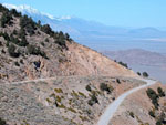
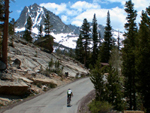
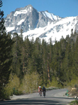
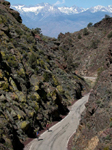 This is really a tale of two roads, as Hwy 168 and White Mountain Road have distinctly different characters. Unlike so many of the other climbs here that begin with the same old same old alluvial fan dance, Hwy 168 is interesting and full of mischief right from the get-go (at least, once you cross those first three, flattish miles leading out of Big Pine). The road climbs for about ten miles, changing pitch constantly. One single sentence can’t begin to describe all the changes it goes through. There are steep, little walls, long, gentle grades, rollers, saddles, washes, and just about anything else you might imagine. The road runs up a canyon along a mostly dry creekbed. Sometimes the gorge is quite wide and sometimes it chokes down to a narrow defile, where rugged knuckles of rock squeeze the road down to almost a single lane. The photo here illustrates one of the more dramatic of these tight spots.
Eventually, the road levels out at a wide spot called Cedar Flat. Midway across this mile-long flat, you turn uphill on White Mountain Road, heading for the Bristlecone Pine Forest. You know about Bristlecone Pines, right? Oldest trees...all that good stuff. This is where they hang out in the thickest abundance. It is a harsh, sere environment, and the challenge of eking out an existence in such unforgiving conditions is at least partly what contributes to the longevity of these tough little trees. They are survivors.
 You begin seeing the twisted pines as soon as you turn onto the access road going up the hill, but you may not give them as much attention as they deserve if you are fighting your own little war with gravity at this point. This road serves up climbing in wholesale job lots. It doesn’t go up all the time, but it does enough of it to make just about any cyclist suffer. In spite of the locals’ claims of 17% grades in places, I can’t remember anything in particular that seemed all that brutal. It’s really the cumulative effect of a lot of feet of elevation gain...a lot of miles of uphill travail strung together. And the fact that the summit busts through the 10,000' ceiling means your lungs and heart are going to be starved for fuel. It all takes its toll.
There is a nice visitor center at the end of the paved road, and a fine loop trail through the forest, if you have any energy left after all the climbing. One other scenic feature I have been forgetting to mention: this climb being over on the opposite side of the valley from the great Sierra Nevada massif, there are numerous places along the road where you are afforded stupendous vistas across the valley to the rugged, snow-mantled peaks. I don’t even bother trying to show a photo of this wide-angle panorama. It’s too vast to fit in one frame.
Once you’ve soaked up all the Bristlecone lore you can handle, it’s time to get off the mountain...take the down escalator back to the valley. And what a great ride it is! White Mountain has a rather sketchy chip seal surface, which requires just a little more care on the descent than is ideal, by my timid descending standards anyway. It’s still a lot of fun, but the real treat is waiting down on Hwy 168: those ten miles down the canyon...ripping through the narrows; flying off the tops of dippity-doo humps, snapping left-right-left around the topsy-turvy-swervy curves...and all of it on silk-smooth pavement, or close enough to it to not matter. This is simply a kick-ass, big-time descent...about as much fun as you can have without breaking any laws or social taboos. (This is not just my opinion either: everyone who has written about this E-ticket ride gropes for the superlatives and the hyperboles. It blows everyone’s doors off.)
South Lake and Lake Sabrina
Now we’re up to Bishop, the biggest, sprawlingest, busiest town along the length of 395. Lots of tourist stuff. Lots of restaurants and motels and galleries and gift shops, plus all the normal American hometown fare, from supermarkets to auto parts stores to Walmarts. But looming over the town--in spite of all that civilization--the mountains are still there...the 12,000' White Mountains to the east and the 13,000' Sierra to the west...hard to ignore from Bishop, in its basin at just over 4000'.
The South Lake/Lake Sabrina route is Y-shaped: one road well up into the mountains--another section of Hwy 168--then two roads forking off to their respective lakes. You could visit the two lakes in either order, but I chose to do South Lake first. Why? Because at the junction, the Sabrina Lake road is in the middle of a substantial climb, whereas the South Lake road is flat...which means on the way back from Sabrina Lake, one would be screaming down the grade, and who wants to break off a good descent to turn onto another road? Makes sense to me!
You can tackle this trek right out of Bishop, but I was hangin’ at a nearby campground--Millpond Park--and started there. In either case, there are three or four miles of nearly flat road getting out to where the climb gets serious. From that point, at around 4300', you climb (most of the time) for the next 18 miles to get to the road’s end at South Lake, at 9835'. Total gain for the climb: just under 6000'. Once again, the average gradient of 6% is mostly meaningless, as the road varies considerably in pitch and in overall character from the bottom to the top.
 Hwy 168 offers up one more huge helping of alluvial fan to get you going on the climb...only about three miles of it in its purest, most stultifying form, but another few miles beyond that where the climb, although actually now up into the mountains, is still a bit short on eye candy or anything very entertaining. Okay, okay...you do start seeing some great, hulking ramparts of stone and lots of scattered wildflowers and pretty Bishop Creek down below the road. I guess my complaint here is that the road itself is not doing much: no twists or wiggles or changes in grade. Just a long, long slog up the mountain.
But this too shall pass, and sooner or later you will encounter flat spots and steeper walls--some painfully steep walls--on your way to the junction of the two lake roads. The South Lake spur starts off easy enough, with some lazily uphill miles--still along the creek--through pretty meadows thronged with quaking aspen and past clusters of mountain cabins. The whole South Lake road is about seven miles long, and the first five pass in this relatively benign way (although you are still climbing almost constantly). It’s a long way from being painful, except the air is getting a little thin. But this pleasant road has a wicked stinger in its tail: two miles from the end, the grade jumps from maybe 5% to 10%. The road narrows from a striped highway to a dinky mountain track, with the creek now a cascade. Finally, in the last brutal mile, the pitch kicks up to 15%, all the way to the parking lot above the lovely lake.
 After the many repeated body blows of the lower miles coming up the grade, these final two miles are a left-right combination upside the head, with the last, lethal section being the haymaker that finally buckles your knees. Unless you are an ubermensch when it comes to climbing, it will take you quite a few minutes to catch your breath at the summit. You can put your recovery time to good use though: admiring the lake and the impressive ring of peaks and crags that cradle the little lake. Now this does look authentically alpine! You could be in Switzerland. I’m sorry I don’t have any pictures of the lake, nor of Lake Sabrina, as both of them are exquistie scenic gems. I was amazed at how--after the rather boring miles lower down the hill--things quite suddenly became quite spectacular.
There is a little snack food kiosk on the lakeshore, but they do not have running water. To refill your bottles and moisten your parched throat, you will have to stop at Parcher’s Resort, about a mile back down the mountain. It’s worth it: they will fill your bottles with ice before adding the water.
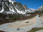
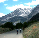
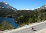
From the summit just under 10,000', you descend to just under 8000' at the junction. Then you have to call your climbing legs back to active duty. Another reason for doing the Sabrina Lake spur second is that it is not as long, nor as steep as the South Lake deal. It’s four miles from the junction to the lake, climbing from 8000' to around 9200'. As you are heading back up into the same terrain you just left on the other road, it’s no surprise that this road behaves in just about the same way. (I had no photos at all of the Sabrina Lake climb, so I threw in one more nice shot of the South Lake ascent. What the heck: it looks the same on both roads.)
 There is, first of all, a long, straight grade running up the side wall of a canyon--this time along the middle fork of Bishop Creek. I’m not sure what the gradient is on this too-long stretch, but I know I found myself cutting some shoelaces back and forth across the road. I’d guess it has to be a sustained 8% or perhaps a bit more. Not quite brutal, but a good, solid grunt near the end of the combined climbs. But wait...there’s more! You finally reach a blessed little flat spot, where you can soft pedal and catch your breath while rolling through a charming meadow along a boggy, marshy section of the creek. However, lurking on the far side of this brief reprieve is the kid brother of that last, nasty pitch at South Lake. Once again, the road necks down to one lane, gets all twisty, and grapples its way up the final mile at something on the high side of 10%...not as bad as South Lake, but still pretty stout work.
The payoff for this final, gasping, wheezing effort is another lovely lake snuggled down in a cradle of magnificent granite spires. Also--much better than the snack food kiosk at South Lake--there is a quaint old chalet-style restaurant, with indoor and outdoor seating, serving basic but tasty chow for hungry hikers and bikers, with a million dollar view off the deck. I rewarded myself for the big climb(s) with a basket of french fries...kicked back on an old sofa, put me feet up, and soaked up the sun and the scenery. Life is good!
And now--once the pommes frites are stowed away--the downhill is there, ready for the plucking. It’s a good downhill, but not a great one. All those long, featureless miles of moderate climbing lower down the mountain translate into long, featureless descending. On the bright side, with a descent this non-technical, you can spare an eye for whatever nice scenery is flying by. Some of the steeper pitches do allow you to pour on the coal in the speed department...50 mph is easy if you want it.
Altogether, from Millpond Park, I racked up 51 miles and 7000' of gain, with about seven of those miles being the flat stuff at the bottom of the hill.
Sherwin Grade-Rock Creek-Mosquito Flat
The main claim to fame for this climb is that, when you reach the tippy top trailhead at Mosquito Flat, you have made it to the end of the highest paved road in California (at 10,250').
The locals call this a 22-mile climb with over 6000' of elevation gain, but that is kind of an arbitrary fiddle...a bit of geographic spin doctoring. The final climb, from the junction with Hwy 395 at Tom’s Place to road’s end is only 11 miles, with 3200' of climbing...some of it over 10%. But the conventional local wisdom is that to get to that final ascent, you have to climb up from Round Valley, way back over by Bishop, down in the 4000'+ region. What you’re then doing is really two or even three distinct climbs, depending on how you define a climb. It certainly is the best way to tackle this package, if only because the first climb in the bunch--Sherwin Grade--is the best part of the whole ensemble.
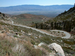
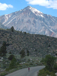
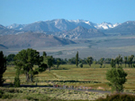 I started again from my camp at Millpond Park, logging an extra 11 miles each way on the valley floor before hitting the first real climb. Instead of a 44-mile round trip and 6000'+ of climbing, I ended up with 66 miles and 7100'. Some of those valley miles were very nice and some were only so-so. I have included a picture of Round Valley to give an indication of how nice it can be. And hooray!...no alluvial fan!.
No doubt the locals have a precise spot in mind for the official beginning of the climb when they say it’s 22 miles long. But I had a hard time telling where the Round Valley rollers left off and the real climbing began...so gradual is that first run up to the rocky hillside. Once you get to Paradise Lodge--a charming old restaurant beside Lower Rock Creek--you know you are climbing in earnest. This is Sherwin Grade, and it meanders back and forth across an open, rocky hillside for about five miles before summitting at 6427'. This is as entertaining as the South Lake approach was boring. Here, the road loops back and forth in a slinky sort of way, like a big lazy snake slithering up the hill.
 Once over the top, there is a jazzy little descent back into the gorge of Rock Creek. It drops 300' in around a mile, and then returns to uphill for four more miles through a pleasant forest of firs and broadleafs. None of this is very steep...easy going. This road, by the way, is identified as Old Rock Creek Road up to the summit, and Lower Rock Creek Road on the north side of the hill. We have been travelling in a northwesterly direction for most of the ride up to this point. Now, after one connector mile on Hwy 395, we arrive at Tom’s Place (a small community of no particular distinction), and the route heads uphill on Rock Creek Road, almost doubling back in a southwesterly direction now, headed for that Ultima Thule of paved roads...Mosquito Flat.
In spite of having cranked right round the compass from NW to SW, Rock Creek is still our constant companion alongside the road...sometimes right there, making a big, splashy show with cascades and rapids, and sometimes wandering off a ways to leave us high and dry.
Overall, this is a nice road. The creek is pretty; the woods are too, and the grade varies occasionally to get you out of the saddle or settled back down for easy tempo work. They say the steepest pitches hit 11%, and that sounds about right. Never killer, but a lot of it: constant uphill effort for over 20 of those 22 miles.
 Nine miles up from Tom’s Place, you hit Rock Creek Lake, where there is an old mountain lodge that serves wonderful fruit pies. But you have to do a 1-mile round trip off on a side road to get to the lodge and the pie. Worth it? Maybe...but I skipped the pie and stayed with the climb, up, up, and up, above the lake. Over those last two miles, the scenery improves a bit...not that it has been all that shabby previously. It’s the usual high-country payoff to which we have by now become accustomed: the higher you go, the better it looks. In the last mile, the road shrinks to one lane again, a la South Lake and Sabrina, and it does get a bit steeper too, although not as brutal as those other two finales. It’s only right that this highest of all roads should finish with a little panache.
Road’s end is another trailhead/parking lot, with Rock Creek doing one last star turn through a marshy meadow. There are no developed conveniences at this turnaround, nor any especially diverting scenic attractions (although it is all very pleasant in the generic, high-Sierra manner). So after a brief snack, a little sun worshipping, and a little streamside meditation, it’s time for payback: a big withdrawal from the gravity bank.
 Nothing too technical about this upper Rock Creek descent. Most of the time, just hang on and let it run. That goes for the miles back down Lower Rock Creek Road as well...altogether, about 16 miles of enjoyable descending...some of it moderately exciting, but most of it simple cruise-control miles. After working back up that 300' bump on the backside of Sherwin Grade (amidst very dramatic rock cliffs), all that ho-hum descending comes to an end. The drop down the south side of Sherwin is a total blast: five miles at about 6-8%, all on perfect pavement, all beautifully engineered for maximum cycling fun. One elegantly curving corner after another, all nicely cambered...this is as good as it gets. If all 22 miles had been this primo, I don’t know if I could have handled the overload of bliss. Five miles is probably about my limit when the going gets this good.
For me, the Sherwin Grade part of this package of climbs was the highlight--both climbing it and descending it--and the highest-paved-road deal was cool, but not as epic as I had expected. Glad to have done it so I can check it off my list, but I probably won’t be back too soon.
Summary
Well, there you have it: more than anyone but a diehard biker would ever want to know about some obscure Sierra climbs. It has taken me about as long to write about these roads as it took me to climb them.
Other thoughts...
Traffic: next to nonexistent over almost all of these miles. A few of the roads to lakes had more vacation traffic, especially when we rode on weekend days. Overall, traffic was not a problem.
Air: for a rider who spends most of his time near sea-level, a week of peaks topping out repeatedly around 10,000' put a big burden on the oxygen delivery system. Even for a tourist, piddling slowly up the grades in a comfy gear, this was constant struggle. To race up these giants, as they do in the Everest Challenge, the Death Valley Stage Race and other hillclimbs--going fast and going anaerobic--it would be an extremely cruel challenge. My hat is off to anyone who can complete those monster rides.
I thought about calling this column It’s Not About the Miles...the point being that between the epic lengths of these climbs and the lack of air to breathe, and--for the week I was there--the terrible heat, one can get thoroughly worn out in a relatively short span of miles. It’s true. I had planned to do at least 100 K every day for seven days in a row. On paper, it looked well within my window. In fact, I only hit 100 K twice, and yet, in spite of logging some really measly miles, I felt like I got my ticket punched every day.
I’m back home now. Tomorrow I’m going out to climb some of those “little” Sonoma County climbs: Harrison Grade; King Ridge; Coleman Valley...steep suckers, but not very long, and with bushels of air to breathe. I’ll get my ticket punched again, but it will take 90 miles to do it, instead of 40 or 50.
Bill can be reached at srccride@sonic.net