
 On The Road
by: Bill Oetinger 6/1/2007
A watershed Moment
This month marks a turning point in the coastal hills of Northern California. The arrival of June means the departure of all but the hardiest of our streams. We don't have any high country where snowpack can accumulate and then drip feed the creeks all through the summer. Nor do we have much in the way of rainfall between the end of April and the end of October. Without those sources of resupply, the poor little creeks just shrivel up and die, leaving behind that classic California landscape known as the arroyo...essentially a dry wash or gully.
Mind you, we won't complain when it fails to rain on our two-wheeled parades for month after month, but I at least do miss the splish and splash of the babbling brooks. I brag a lot about what a wonderful area this is for cycling, not least because of the great scenery, but one thing we don't do very well here is creeks and cascades. I'm a total slut for a good waterfall or even a modestly rippling rill, but to get my freshwater fix in the summer and fall, I have to hie myself off to the Sierra for those lovely snowmelt cataracts or off to Oregon or the far north of California, where regular rain recharges the channels and keeps things on the boil, no matter the season.
 Here, by mid-June, about the only streams left with any water in them are our very modest rivers: the little Russian River and its even smaller siblings, the Napa and Petaluma and Gualala Rivers. Okay, I'm exaggerrating just a bit. There are a couple of dozen other creeks, lagunas, and esteros that still have enough water in them to support a few trout and steelies, and to breed a few mosquitos. But all the little rivulets close up shop for the season.
Perhaps it's because of this relative scarcity--absence making the heart grow fonder--but I feel deeply atuned to our riparian landscape, even when the tap has been turned off. Even without any water actively present, I can appreciate how that water has shaped the land.
Now then, a brief time-out here for a rhetorical question: what do creeks have to do with cycling? Quite a lot, by my way of reckoning these things, as I will attempt to explain with my rhetorical answer. Not long ago I had a conversation about my biking columns with my old friend Robin Dean. He noted that in my recent Chasing Blue Skies piece--an ode to springtime--he had to read two thirds of the way through the essay before he found any mention of cycling. He wasn't really complaining...just pulling my chain the way friends will do. But his point is well taken and deserves a response. I gave him a short one and will try to articulate it more thoroughly here.
I love writing about cycling, and I'm so grateful that I have this little space that allows me to do so...to gab on and on about this best of all possible subjects. But for me, the subject of cycling embraces more than just those topics that most immediately concern bikes: frame building and gear inches and saddle heights; sprinting and climbing and descending; racing and touring and centuries; flats and bonks and crashes. For me, cycling is about more than just riding the bike.
True, the very existence and premise of the bike is wonderful: this clever, simple invention that translates our modest pedal power into forward motion. That in itself is worth more column inches than I will ever have time to crank out. But that is only the start. That only deals with the vehicle itself. What that vehicle does for me, with its self-propelled forward motion, is transport me out into the wider, wilder world. It expands my horizons, both literally and metaphorically, affording me glimpses of new countryside, new possibilities, new ways of considering how the world is put together. This is not simply a visual delight in the pretty eye-candy I see about me on rides. The beauty of the landscape is all well and good, but it's what it implies about the inner workings of the great machine that sets my own mental wheels turning...how all the pieces mesh and meld into this dense, multi-dimensional matrix; this cosmic stew in which we swim.
 So how do creeks and bikes fit into this mix? I should think that would be obvious, but if it's not, just remember this notion the next time you're bombing downhill at 40-mph into a steep, creek-cut canyon, then climbing, sweating and huffing, up the other side of the canyon at 4-mph. How the flow of water has shaped the land ought to be as real as real can be when you're grappling with gravity for every inch of road.
All of this has been on my mind lately because of a set of street signs that has recently popped up on the rural roads of our region. They are official county road signs--white letters on green--and they all have messages such as this: "Entering the Dutch Bill Creek Watershed." There are also new signs at the actual creek crossings. But signs on bridges at creek and river crossings are nothing new. What's new are these watershed signs, almost always where the road summits a ridge. (If you're one of those feisty cyclists who likes to sprint for county line signs and summit signs, then I suggest you add watershed signs to your list of potential "primes." What could be more basic in the way of a border than the edge of a watershed? And if the sign is placed at the top end of the watershed, up on the ridge, why then, it's also going to mark a summit. Two primes in one!)
All I know about the signs I learned from a column in our local paper written by my cycling pal Chris Coursey. (Chris is a real journalist. He got his degree in it. I transferred out of the Journalism school into the Creative Writing school. That's why he's now the pro and I'm the amateur. But it's also why I let him do the research on the article about watershed signs and I steal what he dug up for my column.) You can read Chris' very good take on the topic at the Santa Rosa Press Democrat website, at least as long as the PD keeps the link active. Because he does such a good job of explaining it, I won't attempt to cover all the same ground here. I will just note that the signs came about because of the vision of one local man, Brock Dolman, and with the aid of grant from the California Coastal Consevancy. So far, about 60 signs have been put up, mostly in the coastal hills of southern and western Sonoma County. (This is how I like to see my tax dollars at work.)
The primary point of the signs is to raise people's consciousness about watersheds; about the lay of the land and the flow of water. As Chris points out, when you see Salmon Creek as it flows into the Pacific Ocean, you might never think that that water was collected in a basin of forested hills and grassy meadows covering a large tract of the west county. Chris chose well when he singled out Salmon Creek in his column, for it follows a meandering course, and its creek bed is visible from a number of excellent cycling back roads. For instance, when you are descending from Joy Ridge on Bittner Road--heading almost due east, away from the ocean--you are in fact riding next to the headwaters of Salmon Creek, also heading east, away from the ocean. These wandering waters eventually curl almost all the way around the compass before turning in a northwesterly direction toward the sea.
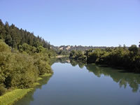
I like knowing this. I find it enlivens my bike rides to be informed that I am moving from one aquatic catch basin to another. One of my other biking buddies--Rich Fuglewicz--works for a civil engineering firm, and in the course of one of their projects, they created a watershed map for the county. Rich printed a copy for me, and I like poring over it. (You know me: never met a map I didn't like, and this one is no exception.) The various watersheds are picked out in different colors, so it's easy to see their shape and size, and easy to see how the whole mess of them is stitched together into a big patchwork quilt. Some of the watersheds are quite large: Salmon Creek, Austin Creek, Laguna de Santa Rosa, Green Valley-Atascadero Creek, Estero Americano, and of course the bigger streams dignified by the name "River". Others are tiny: Cheney Gulch, Freezeout, Bohemian Grove. All of them represent that most critical and fundamental of boundaries: the line where one drop of water flows off this side of the ridge and another drop nearby flows off the other side.
These can be subtle though. There are a pair of signs out on Old Redwood Highway, about a mile south of the town of Cotati. The road here is dang near level, crossing the center of the big, flat valley that has Hwy 101 and Santa Rosa at its center. And yet the water has to flow downhill somewhere, and I had often wondered which way it goes in this region. Now we all know: the sign facing the north-bound traveler says, "Entering the Laguna de Santa Rosa Watershed," which I know joins the Mark West Creek watershed and thence into the Russian River watershed. The sign facing the other way says, "Entering the Petaluma River Watershed," which flows down into San Pablo Bay and thence into San Francisco Bay. Two hypothetical raindrops, falling two inches apart in someone's nearly flat backyard along Old Redwood Highway; nearly flat, but not quite: the water knows which way to go; one drop flows north and one flows south, and they end up entering the Pacific Ocean 60 miles apart.
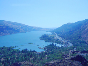 As impressive as that journey is, in the world of watersheds, it's just a drop in a very small bucket. Later this summer, I will be leading a club tour that explores the Cascades of Oregon and travels down the Columbia River gorge along the old historic highway. We'll be riding along many of its tributary streams as well: the Willamette, McKenzie, Deschutes, Sandy, Clackamas, Molalla. Now you're talking serious watersheds! In planning for the trip, I have been reading up on the Columbia and its massive drainage, stretching from British Columbia through Washington and Montana, Idaho and Oregon. This is water at work on a grand scale...a humbling, awe-inspiring scale for us itty-bitty, fast-twitch humans.
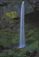
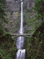 The movement of water and how it sculpts and nourishes the land--and the flora and fauna that live in it and near it--will be the unifying theme of the cycle-tour. If this fails to raise our consciousness or beguile our imagination, then we will have missed the whole point of the journey. But I don't think that will happen. It might be easy enough to overlook a dry arroyo in the summer sunshine of California--easy enough to forget why the arroyo is there and what happens to it in another season--but it will be hard to ignore the mighty, mythic Columbia or the white-water rivers that tumble into it, or the magnificent spills of water--Multnomah and Bridal Veil and Latourell Falls--that plummet off the looming basalt cliffs along the gorge.
I hope we will come home from our travels with a new appreciation for the flow of water, and that we will then see those cool watersheds signs and say, "Oh yeah...right!" And then, cresting the ridge from one watershed to the next, we can flow downstream ourselves, letting gravity have its way with us, dancing down the canyon like a springtime torrent.
Bill can be reached at srccride@sonic.net