
 On The Road
by: Bill Oetinger 1/1/2005
Southern Utah
Ever since visiting the canyonlands of Southern Utah on my honeymoon--31 years ago--I have been wanting to cycle-tour the region. I have been back for family vacations, but never with my bike...until last summer. Finally, after decades of daydreaming and years of planning, I figured out a route that would do a decent job of visiting most of the most famous scenic wonders in this richest of all possible scenic wonderlands.
If you too have entertained dreams of riding your bike through Zion and Bryce and Escalante, but have yet to put the pieces together, read on. I’m going to do a brief summary here of my eight-stage tour.
No one-week tour could possibly hit all the great spots in the area. But this tour visits Capitol Reef National Park, the Grand Staircase-Escalante National Monument, Kodachrome Basin State Park, Bryce Canyon National Park, Cedar Breaks National Monument, and Zion National Park, plus all the miles of killer bike roads in between. It’s a rich, varied sampling of just about every sort of geological extravagance the area has to offer.
Aside from all the obvious attractions of this spectacular region, the neat thing about this particular tour is that it’s a loop. You can leave your car at the start and do the whole thing unsupported. That isn’t exactly the way I did it, though. I dragged a few of my friends along--carpooling to the start--and we took turns driving a van to schlepp our luggage around the loop. (I prefer giving up a day of riding to take my turn shuttling the van, rather than riding every day with my bike weighted down with gear.) But if you prefer the independent, fully-loaded approach, it will work here as well. In either case, this is a campground-based tour. It won’t work for cycling on your plastic and staying in motels. There are too many spots where there aren’t any.
If you’re going to follow along here with any real hope of understanding what I’m describing, I suggest you lay your hands on a AAA map of Southern Utah...that or the very good AAA map of the Four Corners region called Indian Country. Both cover the area of the tour at a scale that’s good enough for this summary. Let’s hit the road...
Stage 1: Cedar City to Otter Creek State Park • 88 miles (or less)
The tour starts and ends in Cedar City, but if you have a sag wagon or shuttle in your plans, you can avoid the town and snip a few somewhat empty miles out of the loop by starting a ways north of town and ending a bit south of town. (That’s what the “or less” refers to.) There’s nothing really dreadful about those semi-urban miles, Cedar City being a moderately attractive and tranquil little burg, but all in all, I like the tour better with those miles edited out.We stashed our excess cars at the Cedar City KOA on the north side of town, where they can be left in relative security for a small weekly rental. If you start riding here, you first have to head north 33 miles on frontage roads along I-15, through the towns of Parowan and Paragonah and off into the middle of nowhere. These are the rather empty miles we chose to avoid with the aid of our sag. We drove those miles and started riding at the point where local Hwy 20 tees into the interstate, and that left us with a stage of 55 miles, all of them better quality bike miles (although not even close to as nice as what you’ll get to in the days ahead).
There’s no question that all the miles on Stage 1--even those on the latter portion of the stage--are inferior to the really awesome spectacle on the coming stages. These are connector miles...the bits you need to do to close the loop. I’ve suggested snipping out a few of those miles, so you may wonder why I don’t snip them all out and drive in my convenient shuttle all the way to where things get good. The answer is that, although the 55 miles from I-15 to Otter Creek Lake are not as impressive as what lies ahead, they’re still good cycling miles and worth doing. Call this stage the opening act that warms up the crowd for the featured attractions to come.
Hwy 20, heading east off the interstate, is a pleasant, two-lane highway with some pretensions of being a modern, fast road. But it’s just quiet and funky enough to remain bike-friendly. It begins with a 10-mile climb that gains 2000'--a robust way to start the tour!--before bombing down the far side of the mountains. Neither the climb nor the descent is all that daunting. It’s typical of what you’ll encounter over and over again on this tour: long, gradual grades.
After a descent that’s about as long as the climb, you tee into Hwy 89 and head north along the Sevier River, dropping--very gradually--into Circleville Canyon. As you pass through the little town of Circleville, you’re at about 6000', but the Tushar Mountains loom up on your left to over 12,000', so the canyon can be rather dramatic. Twentytwo miles of pretty, but relatively uneventful miles on 89 bring you to a right turn onto State Hwy 62, heading east up the east fork of the Sevier. Here, the canyon closes in a bit more, and you begin to see your first big rock: chunky cliffs looming over the road and the river. This is nice, but it’s still just a teaser for what will follow.
Hwy 62 delivers you in 12, slightly uphill miles, to Otter Creek State Park on Otter Creek Lake. This is a decent camp, with the all-important feature of good showers. Overall, the camp is rather barren and drab, sitting on the shore of an austere reservoir. It’s primary virtue, aside from the showers, is that it’s in the right spot for our stages.
Stage 2: Otter Creek to Capitol Reef National Park • 75 miles
I volunteered to drive the luggage van this day, so my impressions are from out of the window of a truck. My biking friends gave the stage mixed reviews, feeling the early miles were boring, but that it got better--way better--toward the end.The first 25 miles are a nearly level run up Grass Valley, with high mountains off both sides. This is classic southwest wide open spaces: views to forever and a long, almost straight road that doesn’t offer a great deal in the way of cycling thrills. (More connector miles, really, but good things are coming...)
Near the little town of Koosharem, the route cuts across on Browns Lane and turns east on Hwy 24, which will be its home for the rest of the day, at least until it turns off into Capitol Reef. It climbs for the first several miles on 24 to a summit at 8410', and after that, the grade will be downhill for almost the entire balance of the stage...over 40 miles. Okay, a lot of that is nearly level, but some of it is pretty intense. The scenery stays pleasant but not spectacular through almost the whole stage, until near the town of Torrey. After that, for the final 15 miles of the stage, things get special.
You have now arrived in the true canyonlands and big rock country of Southern Utah. From here on, pretty much until the end of the tour, you will be rubbernecking and eyeball goggling at every turn. I simply don’t have the space in this setting to wax as poetic and rhapsodic about this scenery as I would like. If you’ve been here, you understand. If you haven’t been here, you’ve seen the pictures and the travel shows. But those hardly begin to do justice to the overwhelming, 360° immensity of the landscape. It is truly one of the earth’s special places.
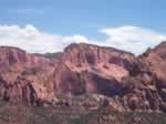
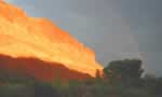 Capitol Reef NP (left) ranked right up at the top of our list of favorite sites along the tour route. It has big rock nearly on a par with Zion, but it has a tiny fraction of the tourists. We pretty much had the place to ourselves, even in mid-summer. The campgrounds are in Fruita (where there are pioneer orchards). The campsites are lovely, although there are no showers. Supposedly you could jump into a pool in the Fremont River, but we just took sponge baths in the camp laundry tub.
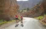
Stage 3: Capitol Reef NP to Calf Creek Camp • 60 miles
Plus optional 12-mile out-&-back in Capitol ReefThere are no filler miles on this stage. It’s epic and spectacular from beginning to end. We added an out-&-back down into the heart of Capitol Reef on Scenic Drive before setting off on the assigned stage, which meant we ended up with about 72 miles on the day. I call this out-&-back optional, but really, you have to do it. These six miles (each way) represent some of the sweetest miles of the tour.
 Scenic Drive (left) is divided equally into a climb and then a descent to the end of the pavement, where the road continues deeper into the canyon as dirt. The grades are easy each way, but just twisty and steep enough to be fun...big fun! I liked this road so much, I did it twice: first, after my truck drive the day before, and again in the morning with my friends.
When you retrace your route to Fruita, you still have more retracing to do: 14 miles, all of them uphill, to the tune of about 1400' of gain, nearly back to Torrey, before heading south on Hwy 12. It’s a big climb, but not killer.
Hwy 12 ought to be listed on some National Register of Heritage Roads, like Hwy 1 through Big Sur, Natchez Trace, and the Blue Ridge Parkway. It’s that special. The route will be on it for much of the next four days, and it never disappoints. This first installment of it may be the best of all. But it isn’t easy: with Scenic Drive thrown in, we logged 8200' of climb on this stage...the most of any day on the tour.
The biggest challenge of the day is a stairstep series of long but gradual climbs to a 9400' summit at Roundup Flat, midway through the stage. Scenery along the climb is less exposed rock and more grassy meadows sprinkled with wildflowers and lovely groves of aspen...an alpine look. We were teased and sometimes tormented by thunderstorms on the first three days of the trip, and we ran into the biggest, baddest thunderstorm of all on this climb, with lightning and hail and knee-buckling thunder on a grand scale. But, typical for desert thunderstorms, it stopped as quickly as it started, and I was dry a half hour later.
That stormy summit was followed by a 15-mile descent which lost nearly 3000' of elevation. Fortunately, the sun had come out and the roads had dried, so we were able to have fun with the gravity candy. The descent ends in the little town of Boulder, and on the far side of town a rather substantial climb of a few miles delivers you to a magic place called The Hogback.
As the name implies, the road runs along the top of a long, narrow mesa, with cliffs toppling away on either side, sometimes just yards from the pavement, and sometimes dropping a thousand feet. It’s beautiful and exciting and possibly a little frightening, if you have a problem with heights. The Hogback ends with a ripper descent to Calf Creek and our campground for the night...a very quiet and pretty camp with a lovely waterfall a short hike up the canyon. The knocks on this camp: no reservations and no showers. But the beautiful creek is handy for a dip.
Stage 4: Calf Creek to Kodachrome Basin State Park • 60 miles
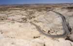 This delightful stage begins with a snappy little descent to a crossing of the Escalante River, then climbs--in fits and starts--through an entirely new landscape...new to us on this tour: unlike anything we’ve seen so far. (That’s typical of the tour: every day offers up a dramatic new geological story, sort of like moving from one wing of an art museum filled with Impressionist paintings into another wing full of Abstract Expressionists.) In this instance, the road twists and turns for about ten miles through a patchwork quilt of pale, almost bone white stone (left).
The middle of this stage is a mix of climbs and descents of moderate proportions, mingled with some more runs across those wide open spaces...pleasant, but not sensational. All that changes at the end of the stage though, as the route leaves Hwy 12 and heads down into Kodachrome Basin State Park. Ten miles off the main highway, this little park is often overlooked by tourists, but is well worth a visit. It’s worth a visit on its own scenic merits, but is especially nice because it’s so quiet...so free of tourist bustle.
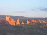 Kodachrome looks like nothing else in the region...another unique geological landscape (left) . Its signature features are its tall spires called sandpipes: hard rock columns standing up out of the surrounding slick rock. The quiet setting and the amazing rock formations made this the biggest, most refreshing surprise of the tour for me. I loved it. We camped in the Oasis group site, which was heaven on earth--grassy lawns under the shade of a grove of cottonwoods--except for some tiny flies that pestered us all afternoon. Showers were a short walk away.
It was a full moon the night we were there, and I hiked out onto the slick rock above the camp around midnight, lay down on the warm, smooth rock, in the soft light of Mama Luna, and had one of those natural epiphanes that would make John Muir proud.
Stage 5: Kodachrome to Bryce Canyon National Park • 26 miles
Many optional miles within BryceThe 26-mile figure represents the distance from Kodachrome to “downtown” Bryce, where the main motels and amenities are (through the pretty Tropic Valley and up onto the Paunsaugunt Plateau). Obviously though, no one would come to Bryce and stop at the first motel. All of the famous vermillion cliffs and canyon walks and knock-out vista points are south of there along Hwy 63, and out along a series of small spur roads to the various overlooks. Before the tour, I calculated I could add 33 miles of park roads to the 26 miles of getting there, but in the end, I logged 72 miles, so I must have found even more little byways to explore. (One of these was in Kodachrome at the start of the stage, but the rest were in Bryce.)
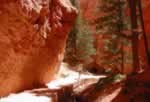 Bryce may be considered the crown jewel of all the Utah parks, but from the point of view of a cycle-tourist, I don’t rate it all that highly. First of all, there are more tourists here than anywhere in the region, except possibly the main canyon at Zion. Second, the main road--Hwy 63--is rather dull as a cycling venue. When you’re on it, you’re mostly buried in the trees in a seen-one-seen-them-all pine forest. You almost never get a glimpse of the famous cliffs and spires and canyons that are Bryce’s calling cards. For all of that, you need to get off the bike and hike (left). The good stuff is there. It’s just not going to fall into your lap while you’re actually riding.
The road isn’t terribly exciting as kinetic poetry either. You have many long, gradual climbs on the way out, culminating at 9105' Rainbow Point, where Hwy 63 ends, but the descents coming back are not really much of a thrill. Most are just straight and uneventful...sit there and coast. Not everyone shares my sense of ennui about Bryce. Many people rate it the highlight of their visit to Utah. You’ll have to decide for yourself.
For a change, we spent this night in one of the many motels near the park (Ruby’s Inn), but there are excellent campsites in the park with showers.
Stage 6: Bryce NP to Duck Creek • 72 or 64 miles
This is the only stage with longer and shorter options. On the face of it, the shorter stage should be easier, especially in light of the fact that the longer one goes up to Cedar Breaks National Monument at over 10,000'. I certainly assumed that, and having been to Cedar Breaks before, I chose the shorter route, looking forward to an easier day. After the fact, I’m not sure it was the right call.Both routes start out the same: across the broad plateau on Hwy 12, heading west from Bryce, down beautiful Red Canyon, and north along Hwy 89 to the town of Panguitch, the biggest town on the tour, outside of Cedar City. Up to that point, things have mostly been downhill, in particular through Red Canyon. But in Panguitch at 6596', Hwy 143 starts climbing, and if you’re heading for Cedar Breaks, it doesn’t stop climbing for 32 miles. Some of that climb is fairly challenging, but most is moderate. Some of the time, the landscape is rather barren and austere, but often the road runs beside pretty Panguitch Creek or along the shore of Panguitch Lake.
At around mile 44, the shorter route turns left and descends alongside vast, rugged lava beds--another new rock formation on the tour--to Mammoth Creek. This descent of several miles at first seems like a nice relief from the climbing, especially considering that there are still the last, loftiest ten miles of the big climb to Cedar Breaks still to do. But, as I learned after awhile, this big descent threw away all the climbing I had done already, putting me back in a hole, before confronting me with something like 13 miles of uphill to camp. In comparison, those on the longer route did their remaining ten miles of climbing, and then enjoyed themselves on monster downhills pretty much all the way to camp.
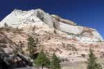
Cedar Breaks looks a bit like a cross between the Grand Canyon and Bryce: lots of colorful cliffs and spires and hoodoos. Not as elaborately gothic as Bryce nor as grand as the Grand Canyon. But still very impressive. In addition to the panoramic vistas across the canyons and cliffs, there are many up-close views of meadows and wildflowers and forests. Having done the low road this time, which was mostly boring pine forest, I would go the Cedar Breaks route if I had to do it again.
Camp was at Duck Creek, a USFS camp on a pretty little lake along Hwy 14. There are no showers in this camp, but I struck up a friendship with a bike-friendly ranger, and he allowed us to use the ranger’s own showers across the road in their administration center.
Day 7: Duck Creek to Zion National Park • 60 miles
Optional 12 miles in Zion CanyonThis stage is mostly downhill. There are some uphill rollers and even a few moderate climbs of some substance, but generally the theme for the day is down, down, down, losing almost 5000' between Duck Creek and Springdale, motel-central at the gates to Zion. Sometimes the descending is almost level and sometimes it’s wild and crazy and as twisted in knots as a plate of fetuccini.
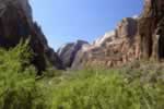
 The day starts with 13 miles of downhill heading east on Hwy 14. Then 23 miles of down--most of it gradual--heading south on Hwy 89. And finally, 24 miles heading west on Hwy 9. Some of it is uphill on the run in to Zion, but the balance is downhill with a vengeance, once inside the park. All the early miles are nice, if not absolutely breathtaking. But the part in the park is epic...off-the-chart fantastic, both for the scenery and for the biking (left) .
There is only one fly in this ointment: halfway through the wonderful, swirling, curling descent from the highlands into the canyon, there is a long tunnel cut through the cliff face, and bikes are not allowed to ride through. We tried to get a dispensation for our group, but no dice. If you have a sag, you load the bikes, drive through, then unload and resume your descent. If you don’t have a sag, you wait at the mouth of the tunnel until someone offers you a lift. It’s a pain in the neck, but it can’t be helped.
The descent on the lower end of the tunnel is even more dramatic than the section in the upcountry, as the road is carved precariously into the sheer cliff face and snakes down the wall in a series of tight hairpins. It’s wild and crazy and fun, and totally appropriate for this hugely spectacular canyon. Once one hits the valley floor, it’s sort of a good news-bad news story. The bad news is that Springdale is about as touristy as a place can be, with campgrounds, motels, restaurants, galleries, and gift shops cluttering up the canyon for miles. The good news is that the heart of the valley is closed to cars...only shuttle buses allowed...and bikes.
 Riding this closed section of out-&-back into the deep canyon would amount to a 12-mile round trip on top of the 60-mile stage. I had planned to do this, but my friends elected to park their bikes at camp in Springdale, change into hiking clothes, and ride the shuttle bus up the canyon. There is actually a good reason for this: while the ride up the canyon would be nice, as it is exquisitely pretty (left) and car-free, the real payoff is the hike that begins at the end of the paved road.
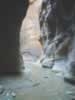 This is The Narrows of the Virgin River, and it’s world famous as a dream hike. After a mile along a paved path, the trail simply drops into the riverbed and hikers bump and grunt their way upstream in the knee-deep water for as long as their legs hold out, with occasional easy stretches over sand bars. True to its name, the canyon narrows to a deep, massive slot canyon, thousands of feet high but often only a hundred feet wide, and sometimes considerably less (left) . Most of the rock walls are nearly vertical and as smooth as glass. As an awe-inspiring, larger-than-life spectacle, it’s right up there with Yosemite Valley.
Our camp in Springdale sucked. We made a bad choice. I don’t think they’re all like that. Still, if I went back, I might opt for a motel on this night, as there are dozen from which to choose. One good thing about Springdale: lots of nice restaurants. We made a good choice in that department and had a wonderful dinner.
Stage 8: Springdale to Cedar City • 57 miles (or less)
Optional 11 miles in parkNow we’re back to the question of whether or not to ride all the way to Cedar City at the end of the stage. If you have a sag, I wouldn’t even consider riding all the way in. But if you don’t have one, it can be done, and it’s a reasonable ride.
The stage begins with 16 mildly downhill and rolling miles along Hwy 9, heading east out of Zion. At the little town of La Verkin, the route hits the low spot of the week: 3313'. (Springdale is at 3913'.) Cedar City is at 5840', so you can see the last 40+ miles will involve a lot of climbing. Gradual climbing, as usual, but still... Moreover, from mile 22 on, the route is either on the freeway (I-15) or on frontage roads near it. That’s not quite as dire as it sounds though. Only 10 miles or so are actually on the freeway shoulder, and some of the rest of the frontage roads are actually quite rustic and charming. In fact, this interstate isn’t all that grim: two lanes each way, relatively light traffic out here in the boonies, and wide shoulders. Plus the scenery is decent.
What we ended up doing was riding about 36 miles along the prescribed route, then doing the optional, 11-mile out-&-back that runs back up into the Zion National Park highlands. After this very worthwhile detour, we called it a day, piled in the sag, and headed for home, leaving the last 20 or so miles into town undone.
 What I like about this approach is that ending the tour with this wonderful out-&-back means ending the tour on the very highest note. It’s a 5.4-mile climb into Zion’s backdoor, upstairs attic...seldom visited, very quiet, and every bit as awesome as the marquee attractions down in the valley (left) ...similar to the way the upcountry of Tenaya and Tuolumne complement Yosemite Valley. And at the end of the out-&-back, the 5.4-mile climb turns into as good a downhill as there is on the whole trip...a tangled, tortured slither down between the big rock walls. Our hardcore descenders were grinning ear-to-ear at the bottom...the perfect place to stop.
This is an awfully long read for what was supposed to be a brief summary, but it still only scratches the surface of what there is to tell about this wonderful region. Normally, I might package all the data up, along with maps and elevation profiles and all that good stuff, and sell it through my little guidebook company, Adventure Velo. But the fact is, I never did a detailed scouting of all the roads and facilities--never collected hard numbers--and I can’t very well sell something with only estimates for miles and climbs and so on. So instead, I’m giving away whatever I do have to whoever might want it. If there is anything more that you want to know, beyond what you see here, fire off an e-mail to me, and I’ll do what I can to assist you.
Thanks to Rich Fuglewicz, Linda Grayson, Eric Smith, and Linda Fluhrer for the photos.
Bill can be reached at srccride@sonic.net